Overwrought Map History Alert!
/My father-in-law forwarded me a piece published at Atlas Obscura back in 2020, entitled
How a Secret Map Brought Down a Pirate Alliance on the Irish Coast: Now archaeologists are using it to search for evidence of clandestine activity. [link]
Ooooh … sexy! Pirates! Espionage!
I looked at the essay because I’m rather jaundiced about the use of detailed maps by/about pirates other than regular charts. The whole “treasure map” schtick is the creation of Robert Louis Stevenson in the nineteenth-century. When you see that the Library of Congress published a guide to treasure maps in their collections, the guide lists official charts showing the locations of shipwrecks! (Although Tom Harper’s most recent exhibition at the British Library, on “Secret Maps,” did include a 1693 manuscript map of part of Bermuda that depicted, so its author claimed, the location of treasure buried by the Spanish 85 years earlier = BL Add MS 5415.g.14, f.33)
Anyway, the Atlas Obscura essay reproduced this map:
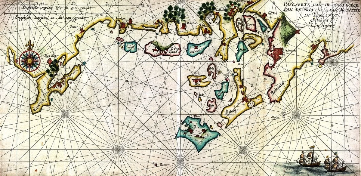
and, lo!, it was plainly printed. That’s ok — some maps were printed in small batches for private distribution. So I did some searching for the map title, and it seems that the chart was actually produced as part of a collection of coastal charts by Hessel Gerritsz., published in Amsterdam in 1612:
Beschryvinghe van de Zeecusten ende Havenen van Yerlandt, VVt-ghegheven Ten bebele van de E. E. Heeren de Ghecommitteerde Raden ter Admiraliteyt residerende binnen Amsterdam (Amsterdam, 1612)
= Description of the Sea Coasts and Harbors of Ireland, Published by Order of the Honorable Gentlemen of the Board of Admiralty Residing in Amsterdam
I say “seemed” because although SUB Göttingen (identified as the holder of the map in the Atlas Obscura article) digitized the work in 2018, so that web crawlers could see the associated metadata, the images of the book are not currently available online. So, I am not 100% sure that the map is actually in the book of charts. This is the one copy of this book that appears in a web search (but then I use a no-AI version of duckduckgo that does not produce much obscure stuff, I’ve found). The Royal Geographical Society added a copy of the book to its collections in 1936 (according to the Geographical Journal) — when I stop drinking coffee and get my act together, I shall have a look in the map library at the Koeman and Van der Krogt bibliographies to see how the book is listed/described there.
Anyway, it is plain to me that Atlas Obscura gave the map the sexy, click-bait treatment … and that just annoys the crap out of me.
Atlas Obscura also botched the source of the map. As published, the map acknowledges that it was actually by John Hunt, an English map maker known in Maine for his 1607-8 aspirational plan of Fort Popham at the mouth of the Kennebec River, site of the short-lived colonial twin to the more successful (and remembered) Jamestown. I’d like to know the attributions of the rest of the maps in the book … are they all by John Hunt?
Enough … need to get ready.