Where are the Ghostbusters When You Need Them?
/Friday’s UN resolution about world map projections shows we are still being haunted by the legacy of Arno Peters
As a map historian with a profound interest in the history of map projections and their use, I feel compelled to write about Friday’s UN resolution … I hope this is interesting to someone out there!
On Friday (4 September 2026), the United Nations General Assembly voted 164–1 (with 6 abstentions) on resolution A/80/L.104, entitled “‘Correcting the Map’: Rebalancing Global Cartographic Representation and Promoting Equitable Representation of the World’s Regions, Particularly Africa.” Video of the assembly’s meeting, with an auto-generated transcript and timed captions, are available from UN Web TV.
This event and the responses to it show that we are still being haunted by Arno Peters’ damnable arguments. They were cursed when Peters publicized them, about fifty years ago, and they seem doomed to torment us even now.
Here, I briefly review Peters’ arguments for his map; see my 23 January 2024 post for much more information about his projection, his tendentious arguments, and the responses thereto. I then get into how the UN resolution’s precursors were plainly shaped by Peters’ rhetoric, and how the UN resolution tried but failed to completely break away from it. And then I briefly discuss how responses to the resolution further echo the responses to Peters’ rhetoric.
All told, we need some grand public event, akin to the Ghostbusters’ destruction of the monstrous Stay Puft Marshmallow Man, to finally get rid of the haunting. Alas, the UN resolution is not it.
World Maps…and Arno Peters
A German public historian, Peters railed in the 1970s and 1980s against the evils of Gerardus Mercator’s map projection of 1569, which he claimed provided the structure of all modern world maps, fostering Europe’s imperialistic spirit. By contrast, he touted the benefits of his own world map projection, which he presented as the only projection capable of showing the globe truthfully. Peters’ powerful rhetoric lodged in the public psyche and has refused to go away. His arguments declined in prominence, but have since persisted and infected public attitudes, despite the fact that Mercator’s projection was never as widely used as Peters claimed and indeed had already been widely criticized before Peters drenched it in infamy.
Indeed, the rise of digital mapping programs mean that every map maker has a great smorgasbord of projections they can choose from, and we now all have our own favorite world map projections, each of which says something about us. Map makers can—and do—use many map projections for world maps other than Peters’ own (which is, frankly, aesthetically displeasing and is now rarely used) or Mercator’s projection. Today, my personal favorite is Dan Huffman’s ironic Usefully Useless Projection, copies of which I insisted be acquired by the Osher Map Library.
Note: Google Maps has for technical reasons (mostly to ensure fast loading of new, continuous data as one pans across the map) used the Web Mercator projection (Battersby 2025). Subtly different from Mercator’s projection, especially in its use of a spherical model of the earth, it is not however used as a world map projection (unless one pulls way out!) but rather as a variant on the military’s Universal Transverse Mercator and on more spatially focused uses of Mercator’s projection for marine charts. The widespread use of these variants and specific implementations might perhaps have shaped the public conception of the ubiquity of Mercator’s projection, but, to reiterate, they have nothing to do with the imaging of the entire globe in world maps. (I suppose Google could have used UTM for its mapping software, but was perhaps turned off by the greater computational complexity.)
One of the several map projections to be developed for world maps in the last decade is the Equal Earth Projection (Šavrič, Patterson, and Jenny 2019). Design of this projection was initiated by the announcement by Boston public schools that they would use various world maps in their classrooms, one projection per grade, starting with Peters’. Like academic cartographers in the 1980s, who proposed the use of the projection created by Arthur Robinson in 1961–63 for Rand McNally (published as Robinson 1974, evidently, from the timing, in response to Peters’ first arguments). Robinson’s projection was neither angle-preserving (conformal) like Mercator’s nor equal-area (equivalent) like Peters’, but sought to minimize the sum of all angle and area distortions. It was notably further adopted by the National Geographic Society (which has since moved on to the very similar Winkel Tripel projection). Now, Bojan Šavrič, Tom Patterson, and Bernhard Jenny proposed a new world map that looked very similar to Robinson’s projection but is equal-area and has very low angular distortions. While noting the Boston schools decision, they did not, I am very pleased to say, go on about the evils of Mercator’s projection; nor does their website.
Even so, Peters’ arresting characterization and distorted history of Mercator’s projection have persisted. Peters’ arguments—quite unoriginal in the few things they got right, and utterly wrong and self-serving in everything else—were (to quote from a draft of a side project I’m working on)
essentially that Mercator’s projection’s was exclusively used in world mapping because of the political implications of its geometry: on the one hand, as a navigational tool it was the foundation of Europe’s maritime, global empires; on the other, its gross poleward enlargement of the continental areas of the exploitative countries of the global North, in temperate and high latitudes, in contrast to the comparatively shrunken and exploited tropical lands of the global South, fostered the imperialistic sentiments of European culture. Mercator’s projection thus stands as both origin and cause of the singular modern/European/Western worldview. Offering a concise explanation for persistent global ills, the myth has dominated commentaries on the cultural significance of modern world maps. Attention is focused inexorably, and solely, on Mercator’s projection and the deceptions of its egregious distortions. Mercator’s projection has accordingly been presented as the cause and the epitome of the supposedly abstracted, mathematized, and singular worldview of rational, modern culture.
The UN Resolution and Its Precursors
The UN resolution was very much shaped by the hauntological myth. It stemmed from the #CorrectTheMap Campaign, which is the work of two advocacy groups, Africa No Filter and Speak Up Africa. It is basically an online petition, together with a bunch of mappy resources, that has the following purpose:
As Africa becomes increasingly central to solving global challenges, it is critical to represent its true scale. That’s why the #CorrectTheMap campaign calls on:
The United Nations, as the global leader in international cooperation, and,
The BBC, as a global leading international media organization
To adopt the Equal Earth projection in their data, reports, and materials that include world maps. With their influence, these institutions can set a new standard and encourage others to follow suit in ensuring Africa is represented accurately as a critical driver of global growth and development. [source]
I do not know why #CorrectTheMap chose to advocate specifically for the Equal Earth projection, rather than one of the other available equal-area projections of similar form (like Eckert IV), but it justified the petition by reference to the deathless claim that Mercator’s projection was the projection for all world maps. The homepage of the campaign’s website declares:
For over 450 years, we have based our understanding of Africa, and the world, on a map that is wrong! …
The Mercator map isn’t just about misrepresenting the size of the global South — it’s about power and perception. This needs to change.
We call the world to correct the map by adopting the Equal Earth projection, which more accurately reflects the true size of Africa.
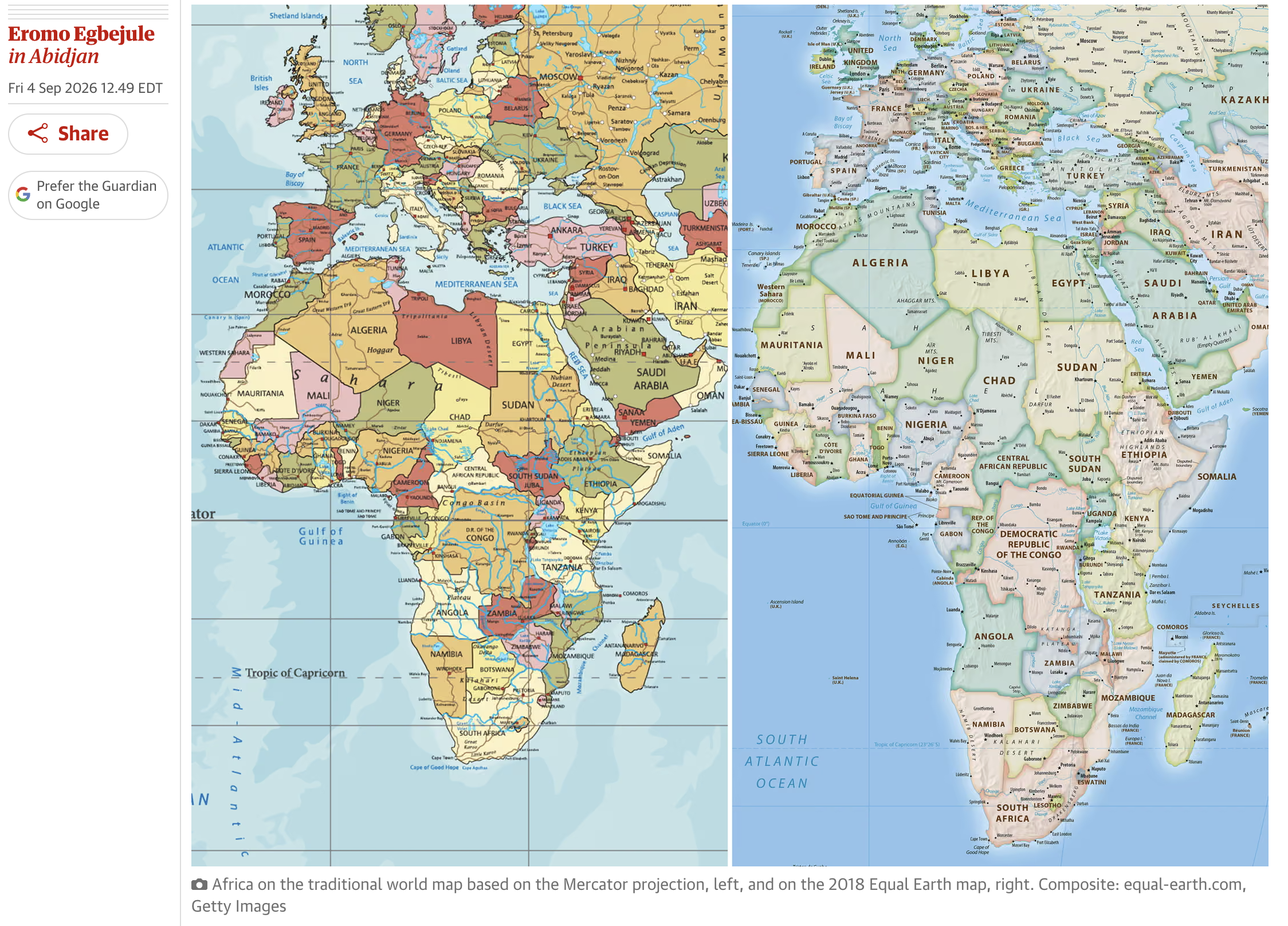
Here’s a comparison from The Guardian of Africa on Mercator’s (left) and Equal Earth (right) projections:
Just over a year ago, in August 2025, the African Union announced its intention to back #CorrectTheMap. In February 2026, the AU’s Assembly of Heads of State and Government approved decision Assembly/AU/Dec.959 (XXXIX), entitled “Correcting the Map of Africa on the Globe,” which had been proposed by the government of Togo (one of the smallest countries on the continent):
12. ADOPTS the Equal Earth cartographic projection to more accurately represent the African continent and correct its representation globally, and URGES Member States to revise national curricula in accordance with the Equal Earth projection
The AU’s rationale again relied on the Mercator myth:
4. AFFIRMS that the Mercator cartographic projection distorts the real size of the African continent, influences perceptions, and negatively affects the objective assessment of Africa's economic viability,…
Overall, if Africa is to take control of its own narrative and its brand, then a better image of Africa’s place in the world is essential (§7), and urged
the African Union, Member States, and nations hosting communities of people of African descent to submit a formal request to the United Nations and its competent agencies to correct the disproportionate cartographic representations of the continent, particularly the Mercator projection, as an act of cognitive justice and reparations, essential to restoring Africa's true place in the global imagination;
The several member states of the African Union subsequently sponsored UN resolution A/80/L.104, which was appropriately introduced to the UN General Assembly by Togo’s representative to the UN, Robert Dussey. The tone of the UN resolution was quite moderate, mostly urging member nations to promote proper education about the nature of map projections. It included rather anodyne language about the importance of maps and, significantly, did not exaggerate the extent to which Mercator’s projection has actually been used
Recognizing that a variety of map projections have been developed over time, using different methods and preserving different cartographic properties, that no single projection can perfectly represent the curved surface of the Earth on a plane, and that each projection is therefore suited to particular purposes, while noting that the present resolution is particularly concerned with projections that preserve the relative sizes of the world’s regions and the proportional representation of their surface areas, and is without prejudice to the established practice with regard to the use of cartographic material for navigational purposes,
Noting that the Mercator projection, designed in the sixteenth century for navigational purposes, remains widely used in educational, media, digital and official materials, despite the considerable distortion of landmasses to the North and South, far from the equator, that it induces to the detriment of equatorial regions,
The resolution also argued that any equal-area map projection should be used in world mapping, preferably but not only the Equal Earth projection. Overall, the resolution included only two actually actionable items:
16. Requests the Secretary-General to provide, until and including at its eighty-third session, information on the implementation of the present resolution, within existing resources, in relevant existing reports submitted to the General Assembly, as appropriate;
17. Decides to include in the provisional agenda of its eighty-third session an item entitled “Promotion of accurate cartographic representation of continents for educational and socioeconomic purposes and strengthening of technical assistance in geospatial capabilities of developing countries.”
So, the UN’s secretary-general must report on how the UN’s many agencies are implementing the principles of the resolution, as best as they can within current resources, and will return to the matter in the 83rd session (opens 5 September 2028).
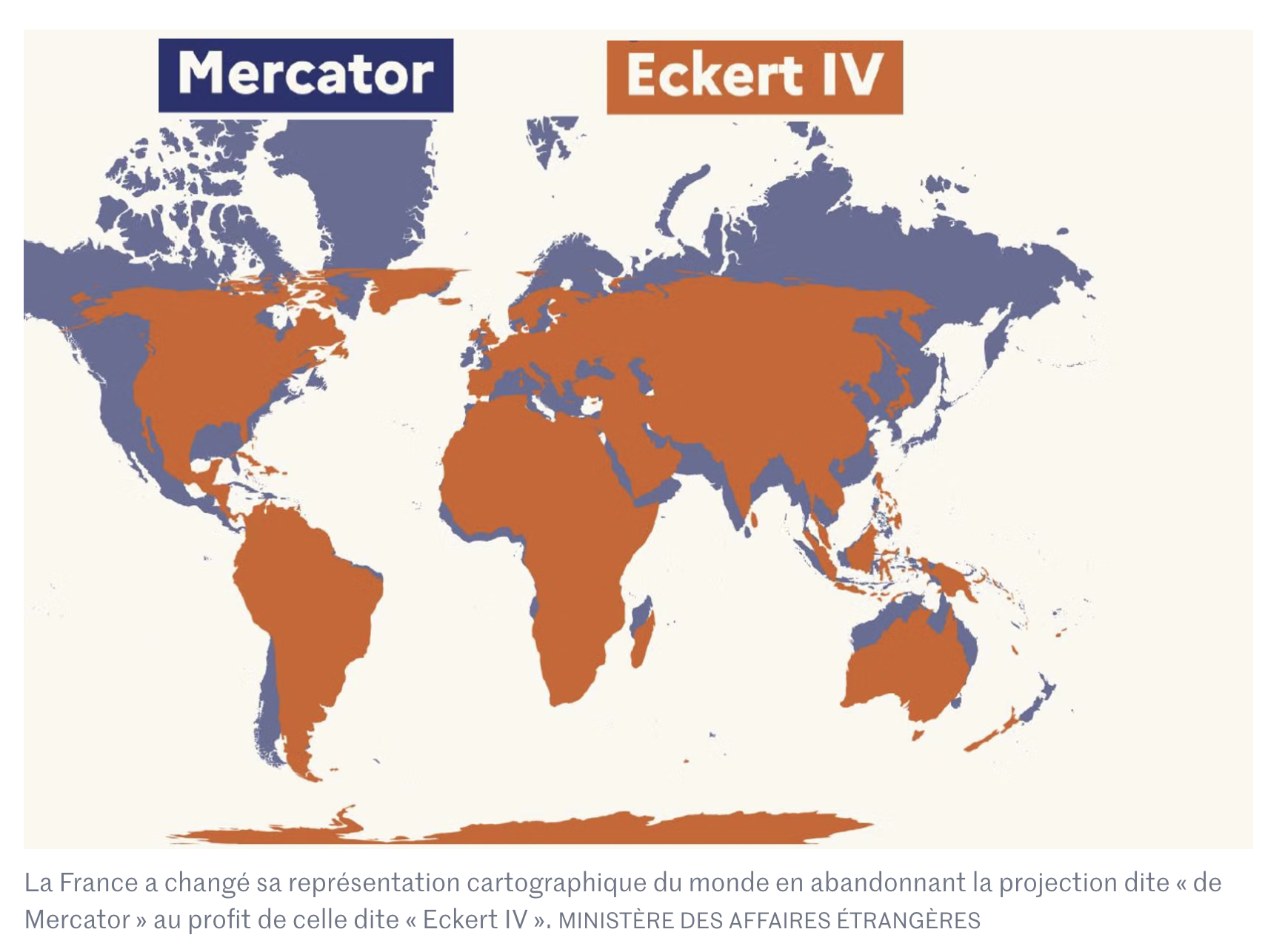
Finally, France announced during the assembly meeting that it supported the resolution and that it would indeed be abandoning Mercator’s projection. Just to confuse matters, however, France has decided not to use the Equal Area projection, but rather Eckert IV:
Responses to the Resolution Echo the Responses to Peters’ Arguments
People might have been objecting to the egregious distortions of Mercator’s projection since the early nineteenth century, but their arguments never had the force of Peters’ claims because they lacked the subversive frisson added by his anti-imperialist, pro-subaltern rhetoric. Peters himself tried during the Cold War to follow an intellectual path between the political positions of East and West and his take on history and cartography was denounced by both sides. Overall, his position expressed other academic trends in the West that led, in the same era, to Women’s History, Subaltern History, Queer History, World History, etc., that opened up huge areas of human history that had previously been closed off. Yet, we all know that history is biased—it’s written by the victors!—but we are disciplined to think of maps as factual, scientific, and objective works. Peters’ arguments about world maps carry that extra frisson, that shock value, that caught the attention of the media in the 1970s and 1980s and that has caught the attention of the media now.
I have seen commentators on social media link to brief statements about the UN Resolution, few addressing the issues in any degree of sophistication (understandable given their brevity), by many media outlets: UN News itself; National Public Radio (USA), which provided some effectively simple world maps for comparison; Politico (USA); The Journal (Ireland); ABC (Australia); The Guardian (UK), which also repeated the common confusion of Mercator’s world map (1569) with his Atlas (1590s) by reproducing an image of his own map of Africa from his Atlas, a map which manifestly has nothing to do with the now infamous projection (curved parallels and meridians!); La Presse (Quebec); CBC (Canada); and Le Monde (France). They all quoted the language of the UN resolution to highlight the usual ghost canard of Mercator’s projection.
One reaction, the official response of the US government in explanation of why it cast the sole vote against the UN resolution, reiterated the Cold War division. It explained that the resolution “cannot be separated from the much larger and more radical ideological project it belongs to – as its most vocal and committed proponents plainly and openly state.” This is effectively the same position that many people took against Peters and still take today: ideology distorts!
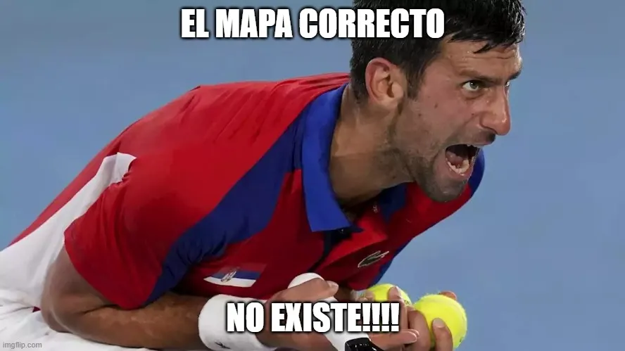
Closely aligned intellectually with this position is the commitment by many commentators to the principle that map projections are purely mathematical and politics is irrelevant. From a geometrical point of view, every projected map, and certainly every world map, must contain geometrical distortion. From a professional and academic standpoint, the task of the map maker is to select the projection most appropriate to the map at hand. In response to Peters, the American Cartographic Association published some little pamphlets, prepared by UW–Madison’s Cartography Laboratory, to educate the public about this selection process (Robinson 1986, 1988, 1991; reprinted Lapaine and Usery 2017, 1–115). In this context, there might be a valid use for Mercator’s projection as the basis for a world map, but not one that I can imagine. But this pragmatism has tended to fall before the basic principle, loudly proclaimed by some people on my social media feed, that “no map can be correct.” Plainly reacting to the name of the #CorrectTheMap campaign and to the title of the UN resolution, these commentators are dismissive on basic principle and not on the merits of the UN resolution. Miguel García Álvarez wittily captured the spirit of this complain in his nice educational blogpost, which he began with a very funny adaptation of a common internet meme:
But this rather exaggerated response hides a far more common conflation of the geometry and content of maps when matters of “distortion” and “correctness” are discussed. The maps provided on the Equal Earth website show the wrong boundaries for Ukraine, so that country abstained from the vote; members of the European Union raised the same reservations [source], although the UN resolution specifically stated that the choice of projection was quite independent of the depiction of political boundaries.
The core issue, one that Peters took great advantage of, is that geometrical distortion is seen as much a failing on the part of a map as the ideological, political, or partisan distortion of content. Both detract from truth.
I must say, however, that I greatly appreciated one commentator on social media (@hayesstw@c.im on Mastodon) who stated that the problem is not that Africa is shown too small, as the #CorrectTheMap campaign complained, because Mercator’s projection, when used in the usual aspect for world maps, is actually true-to-scale close to the equator. The problem, of course, is that more poleward regions are greatly enlarged, so that portions of Africa further away from the equator are not enlarged enough vis-à-vis still more northerly or southerly regions.
And finally, a few commentators on social media have responded to the UN resolution in the same way that many academics did to Peters, which is to say “Yes!” and “Of course maps are political.” In that respect, I think that there might be an interesting project should someone wish to dive deep into the #CorrectTheMap campaign and into the African Union’s work in support of it. Lots of leads in the published documents.
The Cultural Determination of Map Projections
To my mind, the actual historical record is far more complex:
• Mercator’s projection, introduced for a huge wall map of the world in 1569, was not widely adopted either for marine charts or for world maps before 1800.
• the instrumental use of Mercator’s projection for maritime purposes, rare before 1800, is unrelated to the world map except by metaphorical extension; Mercator’s projection did not significantly assist the early modern formation of Europe’s empires, but was a key technology for the West’s global control in the nineteenth and twentieth centuries.
• even in the nineteenth-century, when it was adopted to show an imperialistic view of the world, Mercator’s projection was matched in popularity and significance by other maps of earth, especially those on double-hemisphere projections, but also others invented through the century.
• Mercator’s projection only became dominant in world mapping after 1918, and even then it was routinely challenged by other projections, such as the polar-centric, “air-age” circular maps (like that in the UN logo) and a variety of angular and interrupted polyhedral projections (epitomized by Buckminster Fuller’s Dymaxion maps).
• since Peters proselytized the evils of Mercator’s projection, and with the rise of digital mapping programs, both Mercator’s projection and Peters’ own projection (which is not really aesthetically pleasing) have been increasingly replaced by other projections; indeed, with mapping packages we all have our favoretist world map projections.
The kicker is this: whereas many projections have been created/designed for world maps since 1500, only a handful have actually been commonly used because they align with particular worldviews. This is to say that while world map projections are indeed mathematical in nature—although for multiple values of “mathematics”—their implementation has always been culturally defined, just not in the crude and monolithic ways that Peters claimed.
References
Battersby, Sarah. 2025. “Web Mercator: past, present, and future.” International Journal of Cartography 11, no. 2: 271–76.
Lapaine, Miljenko, and E. Lynn Usery, eds. 2017. Choosing a Map Projection. Cham, Switz.: Springer for the International Cartographic Association.
Robinson, Arthur H. 1974. “A New Map Projection: Its Development and Characteristics.” International Yearbook of Cartography 14: 145–55.
———. 1986. Which Map Is Best? Projections for World Maps. American Cartographic Association, Special Publication, 1. Falls Church, VA: Committee on Map Projections of the American Cartographic Association, American Congress on Surveying and Mapping.
———. 1988. Choosing a World Map: Attributes, Distortions, Classes, Aspects. American Cartographic Association, Special Publication, 2. Falls Church, VA: Committee on Map Projections of the American Cartographic Association, American Congress on Surveying and Mapping.
———. 1991. Matching the Map Projection to the Need. American Cartographic Association, Special Publication, 3. Falls Church, VA: Committee on Map Projections of the American Cartographic Association, American Congress on Surveying and Mapping.
Šavrič, Bojan, Tom Patterson, and Bernhard Jenny. 2019. “The Equal Earth Map Projection.” International Journal of Geographical Information Science 33, no. 3: 454–65. [download from this page]