A Little-Known Facsimile
/Ramón de la Sagra’s facsimile of Juan de la Cosa’s depiction of the New World in 1500
A fun story is the initial reception of Juan de la Cosa’s world map in marine style from 1500. I’m not an expert in the map itself, so details escape me. But somehow it ended up in a Paris book store in the winter of 1831–32. The Baron Charles Athanase Walckenaer (1771–1852) found it and immediately bought it. Walckenaer was an Anglophilic Frenchman with interests in archnology and entomology (don’t google his name if you’re afraid of bugs!), the history of geography and discovery, and the history of literature. His private library was substantial (Anon. 1853) and he opened it to any scholar who needed access. Hossam Elkhadem and others (1992, no. 39) called him the Dutch ambassador to France, and this has been copied by later writers (e.g., Martín Merás 2000), but this is a mistake (Cortambert 1853; Naudet 1855; Michaud and Desplaces 1854, 44:221–37).
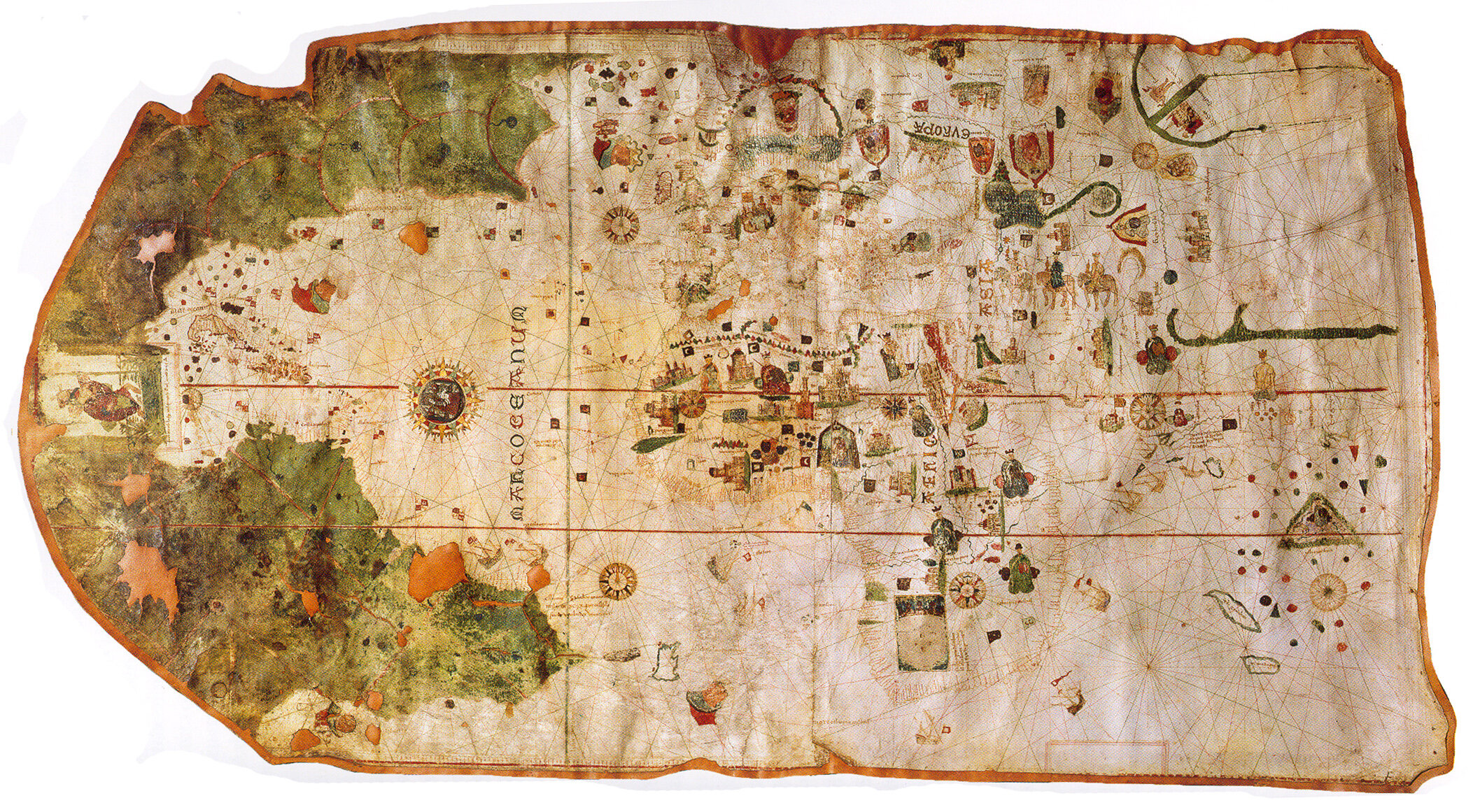
juan de la Cosa’s world map of 1500, now in the Museo Naval, Madrid. This image from the Wikipedia entry on the map.
In the spring of 1832, Walckenaer showed off the new acquisition to Alexander von Humboldt, then visiting Paris from Berlin. Humboldt was captivated by the work and he immediately set out to authenticate it, based on the inscription below the figure of Christ in the far west: Juan de la cosa la fizo en el puerto de S: ma en año de 1500 (“Juan de la Cosa made it in El Puerto de Santa Maria in the year 1500”). As he recorded in an essay dated to 1833:
It would fail the duties of an affectionate acknowledgment, if I did not provide at the end of this preface, a public tribute to Baron Walckenaer, my colleague at the Institute, whose noble zeal for the cultivation of the sciences is not confined to enrich his own labors, but who still likes to help with his advice and the free use of his extensive library, all those who try to travel the same career as him. It was amid the riches contained in this library that I was fortunate to recognize, with Mr. Walckenaer, in the spring of 1832, during my last visit to Paris, the author and the date of map of the world that has resulted in very informative observations. The New Continent is traced there, in 1500, by Juan de la Cosa, who accompanied Christopher Columbus on his second voyage and was pilot of Alonzo Hoyeda in the 1499 expedition, in which there was Amerigo Vespucci. To understand the importance of this geographical monument, just remember that it [was made] six years prior to the death of Columbus, and that the oldest maps of America not included in editions of Ptolemy, or in the sixteenth-century cosmographies that are so far known, are those from 1527 and 1529 in the library of the grand duke of Saxe-Weimar. The last is the most famous because it bears the famous name of Diego Ribero. (Humboldt 1836–39, 1:xxiii–xxv)
Ce serait manquer aux devoirs d'une affectueuse reconnaissance, si je ne rendais pas, à la fin de cette préface, un hommage public à M. le baron Walckenaer, mon confrère à l'Institut, dont le noble zèle pour la culture des sciences ne se borne pas à les enrichir de ses propres travaux, mais qui aime encore à aider de ses conseils et par le libre usage de sa vaste bibliothèque, tous ceux qui essaient de parcourir la même carrière que lui. C'est au milieu des richesses que renferme cette bibliothèque que j'ai eu le bonheur de reconnaître, avec M. Walckenaer, au printemps de l'année 1832, pendant mon dernier séjour à Paris, l'auteur et la date d'une mappemonde qui a donné lieu à des observations très instructives. Le Nouveau-Continent y est tracé, en 1500, par Juan de la Cosa, qui avait accompagné Christoph Colomb dans son second voyage, et qui était pilote d'Alonzo Hoyeda dans l'expédition de 1499, où se trouvait Amérigo Vespucci. Pour concevoir l'importance de ce monument géographique, il suffit de rappeler qu'il est de six ans antérieur à la mort de Colomb, et que les plus anciennes cartes de l'Amérique non insérées dans les éditions de Ptolémée, ou dans les cosmographies de seizième siècle que l'on ait connues jusqu'ici, sont celles de 1527 et 1529 de la bibliothèque du grand-duc de Saxe-Weimar. La dernière est la plus connue parce qu'elle porte le nom célèbre de Diego Ribero.
The map gave Humboldt a direct and almost visceral access to the Great Discoveries that did so much to change (in his and his contemporaries’ belief) the nature of the West, of Western science, and Western morality.
De la Cosa’s depiction of the new world equally enthralled others. Almost as soon as he read Humboldt’s account, the Spanish polymath, historian, and politician Ramón de la Sagra (Ramón Dionisio José de la Sagra y Peris, 1798–1871), then resident in Paris, approached Walckenaer to make a facsimile of the map. In a brief notice, de la Sagra (1842–61, 1:5) admitted that the map showed the whole world but that its depiction of the new world made it truly remarkable:

Ramón de la Sagra, Parte correspondiente a la America de la carta general de Juan de la Cosa, piloto en el segundo viage de Cristobal Colon en 1493. y en la expedicion de Alonzo de Hojedo en 1499. calcada sobre la original que posee el Sr. baron de Walckenaer para servir de ilustracion a la historia fisica politica y natural de la isla de Cuba por D. Ramon de la Sagra Paris 1837, engr. L. Bouffard (Paris: Lemercier Benard et Cie., 1837). Reoriented and digitally enhanced for clarity. Hand colored lithograph, 60 × 88 cm. Courtesy of the Biblioteca Nacional de España (MA00019643). Click on image for high-res version.
As the title suggests, de la Sagra thought he would include the facsimile in his great history of Cuba that he was then preparing, and he listed it at the head of the many facsimiles included at the end of volume 2 of that work (Sagra 1842–61). It seems however never to have been included in the book (Martín Merás 2000, 84n5) and remained a rare, separate publication. At least one exhibition has displayed this fasimile in lieu of the original manuscript work, and without noticing its character as a facsimlle (Elkhadem et al. 1992, no. 39).
De la Cosa’s map would soon be again reproduced in facsimiles that are well known today, in its entirety by Edme François Jomard (1854–62), a detail of Africa by the viscount of Santarém (1841–44), and other details by Humboldt. What I don’t have time to do, nor the language skills, is to research de la Sagra’s entire interest in early maps; it would be an interesting study!
This has been another blip built out of material cut from Maps, History, Theory.
References
Anonymous. 1853. Catalogue des livres et cartes géographiques de la bibliothèque de feu M. le baron Walckenaer. Paris: L. Potier.
Cortambert, Eugène. 1853. Notice biographique sur M. le baron Walckenaer. Paris: Imprimerie de L. Martinet.
Elkhadem, Hossam, Jean-Paul Heerbrant, Liliane Wellens-de Donder, and Roger Calcoen. 1992. Cartes des Amériques dans les collections de la Bibliothèque royale Albert Ier. Brussels: Bibliothèque royale Albert Ier.
Humboldt, Alexander von. 1836–39. Examen critique de l’histoire de la géographie du nouveau continent et des progrès de l’astronomie nautique aux quinzième et seizième siècles. 5 vols. Paris: Librarie de Gide.
Jomard, Edme François. 1854–62. Les monuments de la géographie, ou recueil d’anciennes cartes européennes et orientales. Accompagnées de sphères terrestres et célestes, de mappemondes et tables cosmographiques, d’astrolabes et autre instruments d’observation, depuis les temps les plus reculés jusqu’à l’époque d’Ortélius et de Gérard Mercator, publiés en fac-simile de la grandeur des originaux. Paris: Duprat, Franck, Arthus Bertrand, Renouard, Gide et Baudry, and Delion.
Martín Merás, María Luisa. 2000. “La carta de Juan de la Cosa: Interpretación e historia.” Monte Buciero 4: 71–86.
Michaud, Louis Gabriel, and Eugène Ernest Desplaces, eds. 1854–[65]. Biographie universelle, ancienne et moderne. 45 vols. 2nd ed. Paris: Madame C. Desplaces.
Naudet, Joseph. 1855. “Notice historique sur la vie et les ouvrages de M. le baron Walckenaer.” Mémoires de l’Institut Impérial de France. Académie des inscriptions et belles-lettres 18: 467–508.
Sagra, Ramón de la. 1842–61. Historia física, política y natural de la Isla de Cuba. 13 vols. Paris: Arthus Bertrand.
Santarém, Manuel Francisco de Barros e Sousa, Visconde de. 1841[–44]. Atlas composé de cartes des XIVe, XVe, XVIe et XVIIe siècles, pour la plupart inédites, et devant servir de preuves a l’ouvrage sur la priorité de la découverte de la côte occidentale d’Afrique au dela du Cap Bojador par les Portugais. Paris.


