A Roman map of Britain?
/Here’s a fun little tidbit about which I just got rather confused. I needed to write it up to get it all clear in my head, and I thought I’d share it.
updated 23 Jul 2020 with some material on Stukely’s reaction to the map, cut from MHT.
William Stukeley (1687–1765) was a prominent British antiquary, remembered as a pioneer in archaeology. He dug and mapped a number of sites of pre-Roman Britain, notably the great stone circle at Avebury. He bought a number of documents from an English expatriate in Copenhagen, Charles Bertram (1723–1765), one of which was a 1338 account, De situ Britanniæ (“The Description of Britain”), by one Richard of Westminster, who Bertram and Stukeley conflated with the known medieval scholar, Richard of Cirencester. The “Description” included a map of Britain that Bertram indicated was derived from a Roman original.
The map included a hundred toponyms previously unknown to Stukeley, and looked very much like the Ptolemaic map of Britain, with the eastward turn of Scotland, as Stukeley had seen in several editions of Ptolemy from 1482, 1513, and 1540. Not only did Stukeley think those maps depicted the island in a “poor” and “jejune” manner, even Mercator’s and Ortelius’s maps were still erroneous, so that he thought that Richard’s map “exceeds them all, beyond compare. And the more we consider it, the more we approve.” The map’s geographical outline and content were even better than on William Camden’s analytical map of Roman Britain, first published in the third edition of Camden’s Britannia (1600) (Stukeley 1757, 12–13, 20–40, esp. 21 [quotations]).
Shame, then, that the manuscript and the map turned out to be a fake! (Piggott 1950, 154–63). Stukeley, however, believed it to be real, and popularized the work.
There are two basic versions of this map.
(1) East-Oriented
Bertram published De situ Britanniæ (Bertram 1757; actually printed in 1758 according to the colophon) in Copenhagen within a collection of three medieval tracts on Britain, whose frontispiece featured an imaginative image of medieval monks making and using geographical maps:
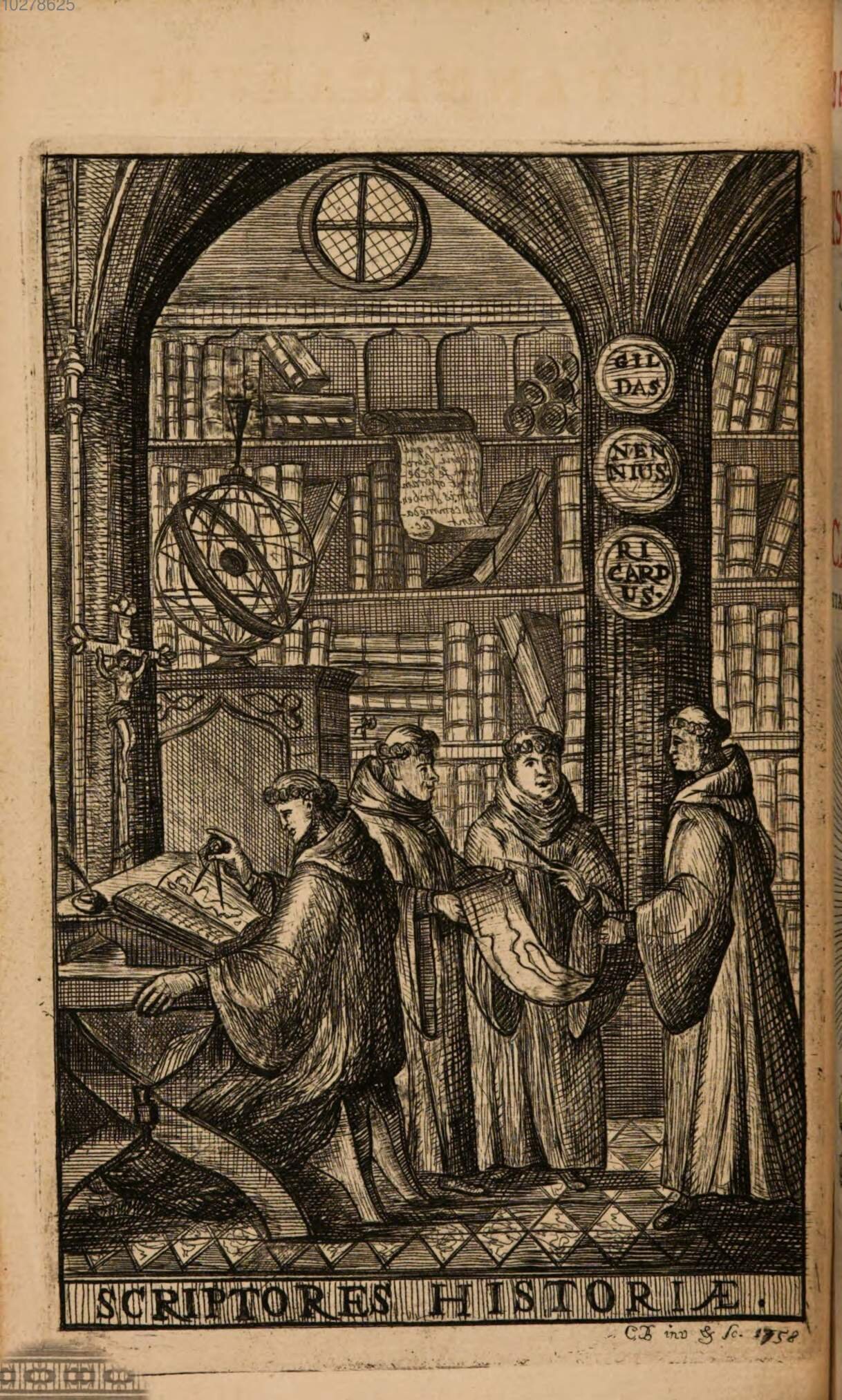
“Scriptores historiæ,” designed and engraved by Charles Bertram, frontispiece to Bertram (1757)
The map itself, which Bertram engraved himself, and which he already dedicated to Stukeley, was bound at the end of the first book of De situ Britanniæ and before the beginning of the second (Bertram 1757, opp. 48):
![“Mappa Brittaniæ facie[i] Romanæ secundum fidem monumentorum perveterum depicta | Tabulam hanc geographicam antiquitatis patriæ Cimelium celeberrimo viro Gulielmo Stukeley. M.D., C.L.M., F.R.S., etc. observantiæ testandæ ergo D. D. Carolus Bertramus…](https://images.squarespace-cdn.com/content/v1/5a317986aeb6255dd87994e4/1586739401043-IBE75EPO7B91OA8ORNQV/034+image+1+bertrem+%28wikipedia%29.png)
“Mappa Brittaniæ facie[i] Romanæ secundum fidem monumentorum perveterum depicta | Tabulam hanc geographicam antiquitatis patriæ Cimelium celeberrimo viro Gulielmo Stukeley. M.D., C.L.M., F.R.S., etc. observantiæ testandæ ergo D. D. Carolus Bertramus 1755 | C. Bertramus ipse delin: ab orig. & Sculpsit” – Wikipedia (original should likely not have been colored)
(2) North-Oriented
Bertrem sent a copy of the map to Stukeley in late 1749 or early 1750, either a manuscript or perhaps an early impression of his copper-plate engraving (Shirley 1990). Stukeley reconfigured the map, orienting it north, for publication in his publication of De situ Britanniæ (Stukeley 1757):

“Mappa Brittaniæ faciei Romanæ secundum fidem monumentorum perveterum depicta”
Further Copies
Subsequent authors further reproduced the east-oriented version of the map, all from separately engraved copper plates. Stukeley himself used that version in the second edition of his Itinerarium Curiosum (Stukeley 1776).
A translation of De situ Britanniæ by Henry Hatcher included a copy of the east-oriented map (Bertram 1809); a copy of this impression is currently for sale by Barry Ruderman Antique Maps; it keeps Bertram’s imprint but adds the copyright indication, “Printed for White & Co. Horace’s Head Fleet Street June 1, 1809.”
And the geographer Aaron Arrowsmith included a further derivative in his Memoir on his 1807 map of Scotland, now with a textual note across the top, an index to the placenames across the bottom, and index guides added to the map itself (A..N across the top, a..i along the sides) (Arrowsmith 1809, opp. 22):

“Mappa Brittaniæ faciei Romanæ secundum fidem monumentorum perveterum depicta”
References
Arrowsmith, Aaron. 1809. Memoir Relative to the Construction of the Map of Scotland Published by Aaron Arrowsmith in the year 1807. London: Aaron Arrowsmith.
Bertram, Charles [Bertramus, Carolus]. 1757. “Ricardi Corinensis Monachi Westmonasteriensis De Situ Britanniæ Libri Duo” [The Two Books on the State of Britain of Richard the Cirencestrian, Westminsterian monk], in Britannicarum Gentium Historiæ Antiquæ Scriptores Tres: Richardus Corinensis, Gildas Badonicus, Nennius Banchorensis [Three Authors of the Ancient History of the Britannic People: Richard the Cirencestrian, Gildas the Badonic, Nennius the Bangorian], 1–60. Copenhagen: Ludolph Henrich Lillie for the author. Bayerische Staatsbibliothek copy.
———. 1809. The Description of Britain, Translated from Richard of Cirencester: With the Original Treatise “De Situ Britanniæ”; and a Commentary on the Itinerary, translated and edited by Henry Hatcher. London: Richard Taylor & Co. for J. White & Co.
Piggott, Stuart. 1950. William Stukeley: An Eighteenth–Century Antiquary. Oxford: Clarendon Press.
Shirley, Rodney W. 1988. Printed Maps of the British Isles, 1650–1750. London.
———. 1990. “The map that never was.” Map Collector 53: 8–13.
Stukeley, William. 1757. An Account of Richard of Cirencester, Monk of Westminster, and of his Works: with his Antient Map of Roman Brittain; and the Itinerary thereof. London: Richard Hett for Charles Corbet.
———. 1776. Itinerarium curiosum: Or, an account of the antiquities, and remarkable curiosities in nature or art, observed in travels through Great Britain. 2nd ed. London: for Messrs. Baker and Leigh.


