‘A Handsome Exhibit of the Land’
/I came to the difficult realization last year that the effort required to complete my larger projects will prevent me from pursuing further my detailed studies in the mapping of early New England and Maine. I will likely never have the time to undertake the necessary archival work needed to wrap up the incomplete essays sitting on my hard drive. Rather than let them succumb to bit rot, as it were, I thought I might make the hard-won information available here. Here’s the first such essay.

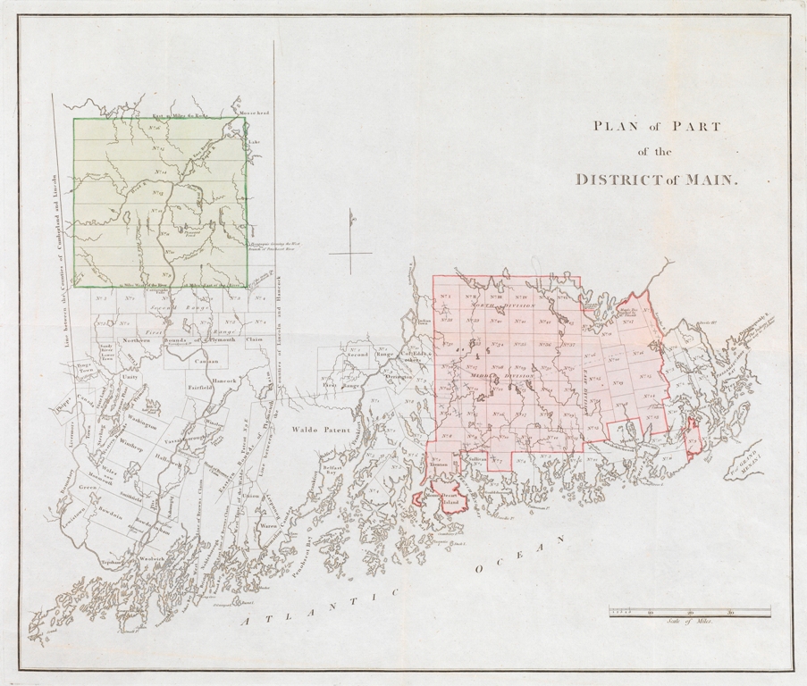
Fig. 1. Plan of Part of the District of Main (n.p, n.d.). “Main” was a fairly common variant of “Maine” in the eighteenth century. Drawn without projection, on a scale of about one inch to twelve miles. Hand-colored copper engraving, 34.5 × 40.5 cm (neat line), 36 × 42 cm (plate mark). Courtesy of the Geography and Map Division, Library of Congress.
I was drawn to this map by the contradiction between, on the one hand, the expectations and assumptions placed on the map by catalogers and cartobibliographers and, on the other, what the map’s form says about its origins. The common assumption is that the map was produced somewhere in the colonies, probably but not necessarily Boston, yet the map looks too well-made for that to have been the case. Ed Thompson asked me about this contradiction, while I was assisting him in the preparation of his bibliography of maps of Maine (Thompson 2010), which prompted me to investigate the Plan’s origins in greater detail.
Resolving the basic issues with the Plan requires engaging with the practices of land speculation in the early republic. Land speculation had been a key element of the economy in eighteenth-century British North America, when land offered something of a secure investment against rampant inflation. It flourished in the early republic when cash-strapped federal and state governments sold off large tracts in order to raise money. These circumstances generated a long series of speculative schemes, some of which were promoted by manuscript and printed maps (see Wyckoff 1988; Bosse 1989; Pedley 1990; Gallo 2012; Verhoeven 2013; Blaakman 2016). Studying the Plan of Part of the District of Main leads inexorably into the history of land speculation in Maine in the early republic and serves as something of a case study of how such a map in this era might have functioned in a “persuasive” manner.
This essay accordingly has the following main sections:
1) Resolving Bibliographical Uncertainties
2) Land Speculation in Maine in the Early Republic
3) Promoting Maine Lands in Printed Plan and Pamphlet
4) Reflections on the Plan as a “Persuasive” Map
1) Resolving Bibliographical Uncertainties
Scholars have not studied the Plan in much detail in part because its rarity has made it rather invisible, but also because it is inherently obscure. It bears no indication of author, engraver, publisher, place of publication, or date. Seemingly fugitive, it lacks an easy hook by which to integrate it into broader narratives of the mapping of Maine. In the meantime, catalogers and cartobibliographers have had to record something about the map. They have accordingly done what they always do in similar situations: they have used the work’s content to make educated guesses about its context. They have not been able to spend much time on the problem, given the map’s relative insignificance, so that their several conclusions about the Plan consistently wrong. Moreover, the Plan was cataloged and described in the predigital era, when it was difficult to study impressions of a printed work held in other institutions. Again, the Plan was too fugitive to warrant the necessary expenditure of effort. For the Plan to be studied in detail, for the self-reinforcing bibliographic inertia to be overcome, there needs to be a digitally competent and somewhat obsessive map historian with a particular interest in Maine. (’nuff said!)
The Plan of Part of the District of Maine offers a case study of the inadequacy of using only content to establish bibliographical context for maps of uncertain origin. The physical form of the map must also be considered. So, not just what the map shows, but how it shows it.
1.1) Dating and Placing the Plan
Analysis of content is always necessary when dating undated maps. Maine ceased to be part of the commonwealth of Massachusetts in 1820; this printed Plan of the district of Maine must therefore have been made before 1820, or at least be based on a manuscript drafted before statehood. Nineteenth-century catalogers accordingly dated the Plan to “[1810?]” (old British Museum printed map catalog) or to “[1815?]” (old New York Public Library catalog).
P. Lee Phillips, at the Library of Congress, seems to have compared the Plan against the early printed maps of Maine, such as

Fig. 2. Osgood Carleton, Map of the District of Maine Drawn from the Latest Surveys and Other Best Authorities, frontispiece to James Sullivan, The History of the District of Maine (Boston: Isaiah Thomas, 1795). Thompson (2010, no. 2). Courtesy of the Osher Map Library and Smith Center for Cartographic Education, University of Southern Maine (Osher Collection). https://oshermaps.org/map/11900.0001
and decided that the Plan shows an earlier phase in the town-granting process. Phillips (1901, 383) therefore dated the Plan to the 1780s (specifically to “[178–?]”), and others have followed suit (Smith 1902, no. 32; McCorkle 2001, 320, no. Me780.1). The NYPL now dates the Plan to “between 1780 and 1789.”
Phillips’ inference was confirmed by James Clements Wheat and Christian Brun (1978, no. 164), who noted that the northernmost town indicated on the Plan along the Penobscot River (i.e., Second Range No. 1 = T1 R2 NWP [North of Waldo Patent]) was officially named Bangor in 1791:

Fig. 3. Detail of An Accurate Plan of 189120 Acres of Land on Penobscot River being the Purchase from the Penobscot Indians by Government on each side said River Together with two Gores of Land, one on each side drawn from the Original by Osgood Carleton (s.n.: n.d., but ca. 1798). The manuscript annotation on this map, labeling “Bangor,” was likely the source of Wheat and Brun’s knowledge of the town’s founding. This is the only known impression of this map (Wheat and Brun 1978, no. 177; see Williamson 1832, 2:552). Courtesy of Harvard Map Collection, Harvard College Library; http://id.lib.harvard.edu/aleph/009539385/catalog
Because the Plan did not name this town “Bangor,” Wheat and Brun thought that it had to have been produced before 1791, which is to say some time in the 1780s.
Wheat and Brun’s certainty was misplaced, depending as it did on the presumption that maps of grants were kept up to date as a matter of course. (This is a manifestation of the ideal of cartography’s preconception of discipline: Edney 2019, 86–91.) In practice, such exercises can only be suggestive, given the complexities inherent to map production.
Further bibliographic uncertainty stems from the improper identification by some catalogers of a second state for the printing plate; a second state would perhaps extend the range of dates when the Plan was printed. The originator of this identification was Jeanette D. Black of the John Carter Brown Library [JCB] at Brown University, who noted significant differences between the JCB’s own impression of the Plan (fig. 4, below) and that in the Library of Congress [LC] (fig. 1) as described by Wheat and Brun (1978, no. 164). Specifically, Black noted that the toponyms transcribed by Wheat and Brun as “Carrigtonka” and “Passamaguaddy” on the LC impression were spelled more appropriately as “Carriotonka Falls” and “Passamaquaddy R” on the JCB impression. The JCB impression must therefore represent a second, corrected state of the Plan. Unfortunately, Wheat and Brun’s transcriptions were wrong and the LC’s impression has the same spellings as the JCB’s. There was only ever the one state of the map.
Some catalogers and cartobibliographers have declined to specify a place of publication for the Plan. Those who have dared to do so have understandably plumped for somewhere in the early republic, most likely in Boston. After all, Boston was the commonwealth’s commercial and political capital. Maps had been intermittently printed there from copper places since 1717, many of them dealing with issues of frontier property (e.g., Edney 2011, maps 1 and 2). It indeed makes sense that the Plan would have been printed there for locals interested in the market for frontier lands.
1.2) The Aesthetics of the Plan
These various inferences by catalogers and cartobibliographers are all understandable, but all are unfortunately wrong. Had the bibliographers had the time to study the Plan’s form in detail, they would have drawn different conclusions about the place of the Plan’s printing. That, in turn, would have directed them to reconsider its content, suggesting an understanding of the map’s intended function.
As I noted at the beginning of this essay, I had long been of the opinion that the Plan was simply too well engraved to have been produced in Boston, or anywhere else in the early republic for that matter. Maps engraved on copper and printed in the North American colonies and the early republic have a generally of poor quality when compared to contemporary maps produced in London and Paris (see fig. 3). Early American maps have uniformly loose and sprawling lettering, shallow line work that prints only faintly, engraved lines of varying width, and cramped layouts with awkward placement of toponyms. Several criticisms survive of the poor quality of engraving in the early USA, such as complaints in 1793 by the Philadelphia publisher Matthew Carey that Amos Doolittle had not engraved lines in a map of Vermont deeply enough to withstand printing many impressions (O’Brien 2008, 24), or those leveled at John Norman’s engraving of large maps of Massachusetts and Maine in the later 1790s (Danforth 1983; Bosse 2011; generally, see Bosse 2000, esp. 145).
The quality of early American map engraving was so uniformly poor that it passes almost completely without comment by Wheat and Brun in their exhaustive cartobibliography of maps printed in America before 1800. They did note how three works had been improved by having their worn, lightly cut lines re-engraved (Wheat and Brun 1978, nos. 730, 888–89). Just once, among all the 919 maps they described, did they comment on the high technical quality of a map, and that map was the Plan of Part of the District of Main! The Plan’s “engraving was well done,” they said (no. 164).
The copper plate for the Plan was, indeed, very well designed and engraved, with tight and well-proportioned lettering and precisely cut lines and hatching (shading). The Plan is the antithesis of cramped: the details of the towns are not crowded, few if any toponyms are crammed into the towns, and the simple neat line is barely even needed to corral the Plan’s restrained design. Nor is the map crammed onto the copper plate; rather, there is a pleasant margin of about one third of an inch between the simple neat line and the edge of the copper plate. The impressions were also well printed, with even and dark ink, on large sheets of fine paper, in the order of 41 × 49 cm, so that the Plan has very generous margins:

Fig. 4. Plan of Part of the District of Main (n.p, n.d.). Courtesy of the John Carter Brown Library, Brown University, Providence, R.I. (Cabinet Cb793 2.1). https://www.brown.edu/academics/libraries/john-carter-brown/jcb-online/image-collections/map-collection
A few surviving impressions, such as the LC impression in fig. 1, have been trimmed; those untrimmed are all on the large sheets. The paper is fine because it had been made in Britain. The JCB’s impression of the Plan (fig. 4) is on English paper with the watermark “1794 | J Whatman.” James Whatman sold his famous papermill to the Hollingsworths in 1794; the Hollingsworths seem thereafter to have used this watermark continuously through 1800 (McMullin 2003, esp. 296).
Overall, the Plan’s proportions are handsome, its engraving clean and precise. This is manifestly not cut-rate work; the quality is carefully understated. The Plan possesses a technical quality that is to be expected from craftsmen in London or Paris in this era, but which was then absent in the USA. Wheat and Brun did not, however, make the logical step to realize that the Plan had not in fact been engraved and printed in North America, but in Europe, and so did not properly belong in their cartobibliography at all.
1.3) Reconsidering the Plan’s Content
The Plan of Part of the District of Main does not show all of the lands laid out in the district of Maine (when still part of the commonwealth of Massachusetts). Its depiction of patents and towns is actually quite selective, as its title suggests. In most surviving impressions, two different colors have been consistently applied to two extensive tracts of land, green in a neat square to the west, a more complex region in red to the east (figs. 1 and 4). These two tracts are those acquired in 1791–92 from the commonwealth by two speculators, General Henry Knox (1750–1806) and William Duer (1743–1799), and subsequently sold to the Philadelphia financial magnate William Bingham (1752–1804) in 1793. There is some variation in the precise selection of towns along the eastern coast that are highlighted in red in different impressions, suggesting further shifting purchases.
It seems reasonable to consider the work as connected to these speculations. Doing so leads to extensive archival evidence that the Plan was made at Bingham’s behest. Frederick Allis (1954) usefully published a large corpus of relevant documents pertaining to Bingham’s speculation in Maine lands, documents supplemented by other Bingham materials in Binghamton, N. Y., and the Lilly Library, Indiana University, and from the archives of the now defunct Barings Bank, London.
This evidence indicates that the Plan was actually engraved in London and in no less than the workshop of William Faden (1749–1836), geographer to the king. Its first impressions were struck in October 1793. Further impressions might have been pulled in or after 1794, as suggested by the paper used for the JCB’s impression (above) but no further changes were made to the printing plate. A strong case can also be made that the source material for the Plan was one or more manuscript maps originally prepared in Boston by the mathematical practitioner Osgood Carleton (1742–1816), with the caveat that the neat copies from which Faden worked were likely drafted by the Philadelphia draftsman Charles de Krafft (d. 1804).
That is to say, the Plan of Part of the District of Main was a work made specifically in support of land speculation. The broad parameters of this speculation needs to be outlined before I can explain the Plan and its specific role.
2) Land Speculation in Maine in the Early Republic
2.1) Knox, Duer, and Bingham
William Bingham’s huge tracts of Maine lands originated in the initial speculations made in 1791–92 by Henry Knox and William Duer. Knox, then President Washington’s secretary of war, already owned a large portion of Maine land through his wife’s inheritance of the extensive Waldo Patent:

Fig. 5. Detail of Plan of Part of the District of Main (n.p, n.d.). See fig. 1. Courtesy of the Geography and Map Division, Library of Congress.
To hide their interest in these huge tracts and so prevent the price of frontier land from rising, Knox and Duer worked in secret through agents, General Henry Jackson (1747–1809) and Royal Flint (1754–1797), respectively.
Jackson and Flint contracted with the Commonwealth of Massachusetts to purchase two separate tracts of land, each of about one million acres (each ca. 40,500 ha). The two tracts are clearly marked on the Plan, the westerly spanning the Kennebec River, the easterly lying beyond the Penobscot River and inland from the coast. The Penobscot tract had originally comprised most of the fifty townships, each six miles on a side, that Massachusetts had failed to distribute in an unsuccessful lottery in 1786. (Allis 1954, 26–27 re failed lottery, 35–78):
![Fig. 6. Plan of 50 townships to be sold by lottery lying between the rivers Penobscot & Schoodic | NB All the Lotts [replaced in ms with Townships], with the Red line are ordered for Sale by Lottery. | Published by order of the Committe [replace…](https://images.squarespace-cdn.com/content/v1/5a317986aeb6255dd87994e4/1557519422454-VIQZRRXFN6I8D8N73I1V/029+img+5.jpg)
Fig. 6. Plan of 50 townships to be sold by lottery lying between the rivers Penobscot & Schoodic | NB All the Lotts [replaced in ms with Townships], with the Red line are ordered for Sale by Lottery. | Published by order of the Committe [replaced in ms with Genl. Court] ([Boston]: [1786]); 34cm × 45cm; 1:253,440. This printed map, with manuscript emendations to the tile—the correction of “Townships” for “Lotts” was made on all impressions that I’ve seen; that of “Genl. Court” for “Committe” was not made on all—was probably intended to advertise the 1786 lottery. Courtesy of the Osher Map Library and Smith Center for Cartographic Education, University of Southern Maine (Gift of Harry Pringle in honor of Peggy Osher). http://www.oshermaps.org/map/45937.0001
Jackson and Flint also purchased an option on a third million-acre tract, the so-called “back tract,” which would run to the north of the Penobscot tract. All told, Knox and Duer paid, via Jackson and Flint, less than $10,000 up front and promised to pay another $400,000 to $500,000 in future installments (Allis 1954, 64). In 2017 dollars, they put down the equivalent of $250,000 with the promise of a further $10–12.5 million. [n1] Finally, they bought up a number of the towns lying between the Penobscot tract and the coast from other landowners and speculators.
Knox and Duer’s financial house of cards was seriously threatened in March 1792. Duer had also pursued a substantial speculation in the fledgling U.S. securities market, based upon privileged information he had gathered when he had served briefly as assistant secretary of the treasury under Alexander Hamilton These speculations in securities proved unsustainable and Duer went bankrupt. In the process, he crashed the stock market for the first time (Cowen 2000). Knox and Duer desperately sought a new investor for the Maine lands, to permit Duer to pay off his other debts and to prevent Knox from being embarrassed by being left holding the bag when it came time to pay the next installment to the commonwealth.
Knox eventually recruited his old friend William Bingham. A merchant, banker, and politician from Philadelphia, Bingham was one of the wealthiest men in the early republic. He had already invested extensively in the new market for lands in western Pennsylvania and western New York. Thinking to have recognized a bargain, and aware of other speculators who also sought to take advantage of the situation—notably the Dutchman Theophile (Theophilus) Cazenove (1740–1811), who represented a Dutch investment consortium—Bingham moved quickly to buy the lands. He worked through his own agent, Major William Jackson (1759–1828). Major Jackson was no relation to Knox’s agent, General Jackson, but was a Philadelphia lawyer who had previously served as secretary to the Constitutional Convention and then as President Washington’s private secretary. In January 1793, Bingham formally took over Duer’s entire share and absorbed Knox’s debt (Allis 1954, 78–103; Brown 1937, esp. 409–34; Alberts 1969, 227–36; also Lewis 1974, 57–58). Having reduced Knox’s share in the speculation by taking on his debt, Bingham agreed to pay him one-third of any profits realized from the future sale of the lands. Otherwise, Bingham now took sole title to all the lands concerned.
2.2) Stages of Speculation as Depicted in the Plan
The three tracts, each of one million acres, represent different stages in the creation and development of frontier lands.

Fig. 7. Detail of the Back Tract on Plan of Part of the District of Main (n.p, n.d.). See fig. 1. Courtesy of the Geography and Map Division, Library of Congress.
The back tract, for which Bingham now held the option, was almost completely imaginary. It was understood only vaguely as being the northward extension of the Penobscot tract and its bounds and extent were defined only in the most general terms. Thus, even though he had negotiated the original option on the tract, Henry Jackson knew only that it reached northwards “to the Devil” (quoted by Allis 1954, 54). The back tract did not—it could not—appear on any maps in January 1793. [n2]

Fig. 8. Detail of the Kennebec Purchase on Plan of Part of the District of Main (n.p, n.d.). See fig. 1. Courtesy of the Geography and Map Division, Library of Congress.
The westerly tract straddling the Kennebec River in Maine’s interior subsequently became known as “Bingham’s Kennebec Purchase.” Colored green in most surviving impressions of the Plan, its existence in 1793 was only slightly more substantial than the back tract. Jackson and Flint’s initial contract with Massachusetts, of 1 July 1791, had defined the tract only in abstract terms. The tract would lie immediately north of the two ranges of towns that Samuel Titcomb and Samuel Weston had surveyed and mapped for the commonwealth in 1790. Titcomb and Weston’s survey had capped the northward extension of the previously ambiguous lands of the seventeenth-century “Plymouth Claim” that were owned and managed by the so-called Kennebec Proprietors (see Edney 2011). To delineate the new tract, the contract specified that its southern limit would first be laid out by extending to both east and west the northern boundary of the northern tier of 1790 towns; the tract’s eastern and western boundaries would then be run northwards from either end of this extended base; the tract’s sides would be long enough so as to form, when connected by a straight boundary across its northern edge, a rectangle encompassing one million acres (including rivers and lakes) plus an undetermined overage reserved for the commonwealth. (The reserved overage would comprise four sections within each putative future town, whose sale would generate funds to support religion and education.) In 1791, just where the baseline extension and the three as-yet-undetermined boundaries of this tract actually ran was anyone’s guess (Allis 1954, 48). Because the payment schedule for the tract would not start until precise surveys of all four sides had been completed, the commonwealth quickly sent Titcomb and Weston back out to delimit this new tract. By the time Bingham acquired the Kennebec tract early in 1793, however, no detailed surveys of the tract’s interior had yet been run. The Plan’s depiction of eight ranges within the tract therefore indicated only the regular manner in which the tract would be subdivided, sometime in the future.

Fig. 9. Detail of the Penobscot Purchase on Plan of Part of the District of Main (n.p, n.d.). See fig. 1. Courtesy of the Geography and Map Division, Library of Congress.
By contrast, the easterly tract had a more concrete existence. Colored red on the Plan and subsequently known as “Bingham’s Penobscot Purchase,” the tract mostly comprised the so-called Lottery Lands (fig. 6). The complications presented by unresolved grants along the Kennebec River and by Indian claims along the Penobscot River had meant that the Massachusetts lottery could only offer relatively unattractive lands situated further Down East that lacked easy access via the coast or rivers. To the east, the Lottery Lands abutted the Schoodic River (today known as the River St. Croix [n3]), to the south, a series of towns already established along the coast. Knox and Duer had accordingly sought to acquire some of these coastal towns, notably Trenton (which included the eastern half of Mt. Desert Island) and parts of Gouldsborough, in order to permit unhindered access from the coast into the interior. Rufus Putnam, a surveyor and prominent land speculator, had already laid out the broad outlines of the Lottery Lands’ three divisions, although detailed surveys remained lacking; Titcomb undertook a survey of the lower Schoodic in 1792 (Irland 1986; Titcomb 1892, esp. 154). Indeed, the spread of white settlement eastward of the Kennebec after the Revolution had prompted Massachusetts in June 1789 to divide up, effective May 1790, what had been the single county of Lincoln into three parts, each appropriately focused on a major waterway: the rump county of Lincoln straddled the Kennebec; the new county of Hancock straddled the Penobscot; and the new county of Washington was accessed by the Schoodic and Passamaquoddy Bay. The Penobscot tract encompassed large portions of the two new counties.
3) Promoting Maine Lands in Printed Plan and Pamphlet
Although Bingham possessed substantial cash reserves, the need to meet the periodic payments for the Maine lands inevitably stressed his finances and other investments. In particular, he met the first payment to Massachusetts by using cash that he had previously committed to a speculation in Pennsylvania. He now had to recoup those initial payments in order to prevent the Pennsylvania deal from turning sour. It would seem, in fact, that his plan right from the start was to place the Maine tracts, as soon as he had control of them, onto the burgeoning European market for American lands. Bingham rather got ahead of himself when, in late December 1792, he wrote that his agent, William Jackson, was about to depart for Europe or had perhaps already departed (Lewis 1974, 58). In fact, Jackson was then still in New York, securing Duer’s agreement to the deal, and Bingham himself had yet to leave Philadelphia for Boston to have the deal ratified by the Massachusetts authorities. Even so, the implication would seem to be that Bingham intended to get the lands onto the European market as soon as possible.
3.1) A Printed Pamphlet to Advertise Maine Lands
In the event, William Jackson would not actually depart for London until June 1793, some five months after Bingham closed the Maine deal. Jackson spent the time collecting descriptions and maps of the Maine lands. Bingham himself used his contacts in Massachusetts to solicit information. Bingham’s old friend General Benjamin Lincoln of Hingham, Massachusetts, gave such detailed and useful answers that Henry Jackson had the questionnaire printed up in Boston and circulated widely to solicit further information; a legislative committee of four representatives and senators responded to the printed questionnaire. The printed questionnaires and the responses thereto are all dated to the spring of 1793 (Allis 1954, 1:175, 176–87 (Lincoln's report); also Brown 1937, 417; Alberts 1969, 232–34).
William Jackson now edited these responses and provided a general introduction to make something of a prospectus for Maine lands. The combined work was printed under the title, A Description of the Situation, Climate, Soil, and Productions of Certain Tracts of Land in the District of Maine and Commonwealth of Massachusetts (Evans 25720; ESTC W37913). Like the Plan, this pamphlet lacked both imprint and a statement of authority. Bibliographers have generally attributed it to either Lincoln or Bingham and from internal evidence have dated it to 1793. Jackson’s subsequent suit for payment from Bingham’s estate made it clear, however, that he should properly be considered the work’s editor and that the work was printed by the Philadelphia printer Zachariah Paulson in early June 1793. Jackson’s suit also confirms that the pamphlet was specifically intended for distribution to prospective investors in Europe (Allis 1954, 1:377–84, reprinted “Major William Jackson’s Statement in His Suit Against the Bingham Estate” [1807], esp. 380–81).
A brief comment in the Description indicates that Major Jackson had intended to include a map. The pamphlet began by first introducing Bingham’s two tracts in Maine and then describing them each in broad terms. For the Penobscot tract, the Description referenced a map:
The tract is divided into townships, conformably to the annexed map, which exhibits the exterior lines of survey, and shews its beautiful and advantageous situation, as bounding on the Atlantic ocean, the Penobscot and Schoodiack rivers.…The rivers that fall into the sea, and the smaller streams that are connected with the Penobscot and Schoodiack, and which are plentifully scattered through the tract, are not displayed on the map, as they could not be delineated accurately, for want of a proper survey which had a view to this particular object.—This is now accomplishing. (Jackson 1793, [3]–4)
It is understandable that the Description did not make another reference to this map within its description of the Kennebec Purchase, given that that tract had only yet been surveyed in the barest outline.
No copy of the Description is known with a map bound within its paper wrappers. In fact, it is certain (see below) that no map was printed in Philadelphia to be inserted into the pamphlet before binding. Wheat and Brun (1978) were therefore wrong to infer from the textual reference that a map should have accompanied the pamphlet, to which they assigned a therefore spurious entry in their cartobibliography (no. 167).
3.2) Preparing and Printing the Plan
The plan in the Description would have been derived from the “maps and drawings of the lands” that William Jackson took great pains to collect on Bingham’s behalf (Allis 1954, 1:381). Jackson undoubtedly drew upon a well-established practice in New England in which officials and landowners had surveyors’ manuscript plans of individual towns or groups of towns compiled into more general maps. The purpose of these compilations was to help unravel, usually in the context of some property dispute, the complex spatial relationships that had developed through the land-granting process. A few were even printed. The compilations were rather hybrid in that they looked like the direct product of property surveys but were reduced to scales more appropriate for regional maps (see Edney 2007, 2011; also Edney 2003).
Jackson also had his collection of maps compiled into at least two neat manuscript maps, one small and one large. Jackson referred in a letter to Bingham to the “small manuscript map,” suggesting that there was at least one other, larger, manuscript map (Jackson to Bingham, London, August 1793, in Allis 1954, 1:288-95, esp. 291-92). A later document referred to the printed maps and to the “large manuscript map” that Jackson had left behind in London (The Baring Archive, DEP 3.1.26, Baring & Co. to Alexander Baring, [London], 29 Apr 1796).
It is quite likely that Jackson employed Charles de Krafft to draft the maps. De Krafft was a local Philadelphia surveyor and draftsman who was active from ca.1783 until ca.1800 and who is known to have made neat copies of many maps and plans for clients living in Philadelphia or elsewhere in Pennsylvania. [n4] In particular, de Krafft prepared a neat manuscript copy of the Plan now in a collection of Bingham’s papers at the Lilly Library, University of Indiana: “Plan of Part of the District of Main | A true Copy, done from the Original Draft” (W. Bingham MSS, VII Property, Oversize 1). It is unclear precisely when De Krafft drew this map, but the presence there of a few small features not present on the printed Plan—such as the location of “Jones’s [mill/trading post]” on the Kawahskitehwock River (the modern Machias River) at what is now Machias—and it’s larger size strongly suggests that it was indeed derived from the same source as the Plan and perhaps represents the “small manuscript” from which the Plan would be derived (below).
Jackson held off getting a map engraved and printed until he had arrived in London to sell Bingham’s Maine lands. [n5] Jackson had sailed from Philadelphia on 16 June, immediately after seeing the Description through printing and even before the printer could issue an invoice. He reached London in mid/late July, armed with letters of introduction and credit from Bingham. In his very first letter back to Bingham, dated 25 July 1793, after confirming that the British were indeed interested in buying frontier lands in America, Jackson observed:
I have not yet determined who I shall employ to engrave the map, but, within a few days, I shall ascertain who is most likely to execute it well, and on good terms. (Allis 1954, 1:282–84, esp. 284).
That is, Jackson and Bingham had decided not only that a map was a crucial element of the process of selling the Maine lands, but also that it was to be produced in London. Jackson hinted at two criteria for the work: it had to be of high quality but of relatively low cost; engravers in Philadelphia or New York might have been cheaper, but no one could ever say that American engravers at the time could match the quality of skilled, specialized line engravers in London, Paris, and Amsterdam.
The continuing story of this map project can be traced through Jackson’s subsequent letters to Bingham. In August 1793, Jackson wrote that he had found a skilled engraver to take on the task; he began by reaffirming the need for an elegant map, perhaps because the price could be considered to be rather high:
Finding that much depends on a handsome exhibit of the land, I have given the map, from which the plate is to be engraved, to Mr. Faden, the King’s geographer, who promises to complete it in about five weeks from this time, and he supposes the cost will be about twenty guineas [i.e., £21, or £2,250 in 2017 (n1)]. The size will be half that of the small manuscript map, which will be sufficiently large to give a very distinct view of the coast and the country. (Allis 1954, 1:288–95, esp. 291–92)
William Faden then ran perhaps the most prominent and accomplished map engraving shop in London (Worms 2004; Worms and Baynton-Williams 2011, 221–25). Yet production did not proceed quite as quickly as planned, as Jackson admitted in the postscript to his next letter in late September: “I believed I should have been able to have enclosed some copies of the map, but Mr. Faden tells me it will not be finished before next week” (Allis 1954, 1:302–11, esp. 311). Jackson finally sent impressions of the map to Bingham in Philadelphia early in November 1793: “I enclose to you the plan of the Main lands which I have had engraved here. I hope you will approve the style in which it is executed” (Allis 1954, 1:313-17, esp. 315). Again, Jackson sought to offset the cost with the elegance required for a map intended to promote property sales to sophisticated Europeans.
Further correspondence strongly suggests that the printed map and pamphlet were understood by Jackson and the potential European investors to be if not a single entity then at least so complementary as to be routinely mentioned together. After almost two years in Europe, mostly in London but also in Paris and Amsterdam, Jackson left in April 1795 to return to America. By then he had highly interested Sir Francis Baring (1740–1810), a prominent English banker and an old friend of Bingham’s, in acquiring the Penobscot Purchase, although the deal was not yet finalized. With his departing letter to Baring, Jackson sent him a variety of documents, including a “Letter from General Lincoln to Mr. Bingham” and “Answers to Questions proposed to a Committee of the Legislature of Massachusetts”—i.e., the principal components of the Description—together with “Two Manuscript Maps of the Land” and “Copperplate ditto” (Allis 1954, 1:372-74, esp. 374). A couple of years later, in 1796, when Sir Francis sent his son Alexander (1774–1848, cr. Baron Ashburton 1835 [n6]) to America to inspect the Maine lands, Sir Francis directed his son to use and annotate both the pamphlet and map:
We have got the printed Books left us by Major Jackson to which you will make such additions as you may think proper in order to include the new purchases, improvements, etc. We have also got his Maps with a large manuscript Map & which must of course be varied [i.e., modified/corrected] in consequence of the additions. (The Baring Archive, DEP 3.1.26, Baring & Co. to Alexander Baring, [London], 29 Apr 1796)
Alexander had to annotate both printed works—as well as a separately identified manuscript map—because Bingham had by 1795 exercised his option on the back tract north of the Penobscot Purchase and was seeking to sell it as well to the Barings. Finally, once the Barings had bought the Maine lands from Bingham, they in 1797 sought to sell them on to Dutch bankers; at that time the Barings also appear to have yoked the pamphlet with the map in their reference to “The printed description of the District now in question published by Mr. Bingham, with a Map of the same” (The Baring Archive, DEP 3.2.58, Messrs. Hope, “State of Property in the District of Maine, Views in that Investment, and means proposed for attaining them for the information of Mr. John Richards,” London, 5 Aug 1797).
3.3) Plan of Part of the District of Main
The problem with all of these archival references to a printed map of Maine is that they neither describe the printed map nor specify its title. Several factors nonetheless indicate that the map printed by William Faden was indeed the Plan of Part of the District of Main.
First, as noted above, the Plan’s aesthetic is certainly indicative of its having been engraved and printed not in Boston, Philadelphia, or any other fledgling publication center in the U.S.
Second, there is a marked lack of other maps that fit the bill. All the other maps of part or all of Maine known to have been printed in the 1780s and 1790s have unambiguous imprints and most were produced as integral parts of books (Smith 1902; Eckstorm 1939; Wheat and Brun 1978, nos. 160-79; McCorkle 2001, 320-21, nos. Me780.1–Me799.1; Thompson 2010). Only the Plan so clearly focused on Bingham’s tracts: all the other maps that encompassed all, or most, of Maine printed before 1795 were small-scale, regional maps with little detail. Even John Norman and John Coles’s huge, twelve-sheet map of New England, published in Boston in 1785, depicted Maine as mostly empty wilderness (Bosse 2000). This situation continued with the first printed map to specifically frame the district, which appeared only in 1793. It was not until 1795, some two years after the Plan had appeared, that the major land tracts and towns of Maine would be indicated in a commercial publication, and then only on a low-resolution map of the whole district (fig. 2) (Thompson 2010, nos. 1 and 2):
Third, there is the congruence between the Plan and a surviving manuscript map of the Kennebec valley that had been prepared by the Boston mathematical practitioner Osgood Carleton (Maine Historical Society, Map FOS 55). This manuscript is precisely the kind of compilation of survey plans that Major Jackson set out to collect early in 1793. Although untitled and undated, its content—especially its depiction of the Kennebec Purchase, derived from Weston and Titcomb’s plan of April 1792, and its identification of Henry Jackson and Royal Flint as the owners—securely dates its compilation to 1792. It is possible that Carleton had been employed by commonwealth officials to compile the map, but David Bosse’s thorough research has uncovered no formal connection between Carleton and the commonwealth government until January 1794, when Carleton proposed a scheme for a comprehensive survey of Massachusetts and Maine. (That proposal eventually produced the two sets of wall maps of Massachusetts and Maine, published in 1798 and 1800–01, for which Carleton is best known today: Danforth 1983; Bosse 1995; Thompson 2010, nos. 3–8). It is more likely that Carleton was employed by Henry Knox and William Duer, or by their agents Henry Jackson and Royal Flint.
Carleton was certainly the logical choice to compile maps for the speculators. [n7] Having pursued a number of public projects, he was then probably the most prominent mathematical practitioner in Boston. He kept a mathematical school, where he taught surveying and navigation; he made regional maps; he published and sold almanacs, maps, and other mathematical books; and he surveyed many properties in and around Boston (Bosse 1995, esp. 149, 151–54, 156, and 158). At the same time, as a founder member of the Society of the Cincinnati, he would have been well-known to Knox, another Boston native who had been the prime mover in creating the society in 1783. Indeed, Knox would in 1798 nominate Carleton for a position in the army (Bosse 1995, 156n75, 161). Bosse (1995, 154) supposed that Carleton established himself “as an authority on the geography of the District” through his preparation of a map of Maine published by Jedidiah Morse in 1793 (Thompson 2010, no. 1), but given that Carleton’s interest in Maine had a slightly earlier origin we might now suggest that Morse approached him to make a map of Maine because he was already expert on the subject. Certainly, Carleton continued to supply various maps to Bingham and other speculators and land developers interested in Maine; this aspect of his work seems to have run in parallel with his subsequent mapping activities for the Massachusetts authorities (Bosse 1995, 154n64–65).
It is therefore logical to presume that, as Bingham and his agent William Jackson pulled together materials for promoting the sale of two-to-three million acres of frontier land to European investors, they relied on Carleton’s manuscript compilations of survey plans. These were not necessarily up to date; between them, they evidently lacked any reference to the founding of Bangor in 1791. The limited nature of Carleton’s sources is further suggested by the Plan’s indication of the boundary of Lincoln and Hancock counties, but not that between Hancock and Washington counties. That is, the Plan was assembled from several plans of discrete surveys rather than being extracted from some large “reference” map or archive about Maine that was kept up to date. (Of course, such an idealized archival representation did not then exist).
The fourth factor indicating that the Plan was indeed the map printed by Faden and then distributed to the Barings and other potential purchasers of Bingham’s Maine lands is the survival in the Baring Archive of three impressions of the Plan, each annotated in a manner reminiscent of Sir Francis’s 1796 instructions to Alexander to update the map (above). One impression bears a few pencil annotations: several towns close to the Penobscot are marked with ‘x’s; moreover, two possible roads are indicated, one running east-west across the Penobscot grant and the other joining the flagged towns with Gouldsborough on the coast, where the Barings thought to establish a major entrepôt (The Baring Archive, DEP 3.4.3.1). The second impression was extensively modified in manuscript by Alexander Baring himself, as part of his proposal to develop the optioned back tract; he originally sent it in a letter to Hope & Co., from Philadelphia in May 1796 (Allis 1954, 1:643–70). Alexander glued on a second sheet of paper to show the long and narrow back tract that ran northwards all the way to the St. John River. This map also includes the approximate routes of the roads to be built across the lands (The Baring Archive, DEP 3.1 append.). The third impression is neatly annotated in manuscript, to show both the back tract on a second sheet of paper and the towns that had in the meantime been created between and joining the Penobscot and Kennebec purchases (The Baring Archive, DEP 85.5.4.). All the other maps in the Baring Archive pertaining to the Maine lands are manuscript copies of surveyors’ plans, Carleton’s compilations, and rather fanciful projections of Gouldsborough as the new Philadelphia of the north; none were printed.
Thus, the Plan of Part of the District of Main is the map that William Jackson had engraved and printed in London.
3.4) Bibliographical Conclusion
Therefore, we can conclude that the Plan of Part of the District of Main was likely based on a design completed by Osgood Carleton in 1792 or 1793. It was engraved in London by William Faden in later 1793 and first printed in October 1793. Further impressions could have been pulled as needed by William Jackson or the Barings, who took possession of the plate, as they continued to tout their lands to interested purchasers. Indeed, once the Barings had contracted to buy the Penobscot Purchase from Bingham, it seems that they had new impressions pulled, or used existing impressions, and colored them in a new manner to show only the eastern lands in red (this is the case with the impressions in the Baring Archive).
So, a bibliographic entry to the map might be as follows:
Carleton, Osgood (attrib.). Plan of Part of the District of Main. Engraved by William Faden. [London]: [1793].
4) Reflections on the Plan as a “Persuasive” Map
Made and used to sell lands in Maine, the Plan of Part of the District of Main might be called a “persuasive” map (Mode 2017). But how did it persuade?
One of the things lacking on the Plan was an indication of roads into the interior and of ports to connect to the wider world. This is a telling lack. Robert Alberts (1969, 232) summarized General Lincoln’s comments in the Description to a simple formula: “Only two things were needed to make Maine a North American Eden: roads and development capital.” When Bingham wrote to a potential investor in the Maine lands, in May 1795, he sent new manuscript maps indicating
the rivers which have been recently surveyed by Peters, exactly designated, which exhibits this country in the most favorable point of view, as relative to the distribution of water, as well for the purpose of establishing mill seats, as for watering meadows and forming the means of communication for conveying the produce to a market. (Allis 1954, 514-15, William Bingham to David Cobb, Philadelphia, 24 May 1795)
In terms of the kinds of information that potential buyers of smaller tracts or particular lots would need, the Plan was clearly lacking.
The Plan’s purpose was more legalistic and administrative, functioning at a higher level of speculation among financiers rather than guiding the sale of particular towns or lots. The principle was revealed by Sir Francis Baring in a letter to his son, Alexander, when the latter was touring Maine and New Brunswick to assess the value of possible lands first hand, not only Bingham’s tracts. [n8] Sir Francis requested Alexander acquire or make
a general map taking in as much of Massachusetts [i.e., Maine] as may be convenient on one side, and extending at all events to the British boundary of the River St. Croix. ... If engraving or printing is dear or difficult in America, a great deal may be done and with dispatch, in this Country, for a few hundred pounds. My object is not only to convey information generally to others, but that we may be enabled to correspond about districts, or parts, with perfect intelligence on both sides, whilst it will serve the important purpose of enabling our successors or representatives to understand the business ab origine in case difficulties should arise when we are no more. (Sir Francis Baring to Alexander Baring, London, 22 July 1796, The Baring Archive DEP 3.5.35)
Sir Francis’s expectation that such a map should be printed is crucial: alterations to a printed map were easily noticeable, so the map’s printedness gave it an archival stability (see Edney 2007).
As a well-executed map, the Plan therefore gave Bingham and his agents a fixed and stable image that would enable negotiations, restrain their complexity, and transmit institutional memory. It reassured potential buyers that the land had been surveyed and was known. Such a map also had to live up to the expectations of European financiers. “A handsome exhibit of the land,” as William Jackson called the Plan, could only have been prepared in London.
Yet the rhetorical power of the Plan did not rely on the quality and effect of its design. In the modern era, “persuasive maps” are images that circulate widely and indiscriminately, in magazines, as posters, etc. They rely on their visual appeal to attract and hold the eye of whoever might happen to see them. In such mapping, the burden of representation seems to fall squarely on the map maker who seeks to create an effective image (i.e., images that make an effect!).
The Plan, however, was not broadcast broadly and indiscriminately. Like the Description, the Plan lacked imprint and statement of authority. Both works accordingly manifest a personalized form of print usually deemed characteristic of earlier centuries, in that the printed works were not intended to be distributed through the marketplace but were disseminated privately (see Edney 2010). Together, the Description and Plan resemble the printed legal documents and their associated maps concerning several colonial boundary disputes heard by the Privy Council (Edney 2007). The authority and validity of such pieces stemmed not from their place within the public marketplace of print, where they would be judged and evaluated in part by their content and in part by the reputation of their authors and publishers, but from the personal (familial, social, financial) relationships between the person giving them out and their recipients.
The Plan of Part of the District of Main was undoubtedly made to help sell lands, but it was significantly limited as a work of persuasion. Its audience was the grand speculator interested in vast tracts of land. Yes, the Plan needed to meet a certain threshold of technical quality, but its rhetorical power resided more in the who was distributing it than in what it showed, or how it showed it.
Appendix: Known Impressions of the Plan
The Baring Archive, London. (http://www.baringarchive.org.uk/) 3 impressions:
DEP 3.4.3.1 – with pencil annotations – low-resolution image online
DEP 85.5.4 – with extensive annotations and westward extension
DEP 3.1 append. – Alexander Baring’s annotated impression with northward extension.
British Library, London.
Maps 73270.(4.)
John Carter Brown Library, Brown University, Providence, R.I.
Cabinet Cb793 2.1 – fig. 3 above – high-res version online
Lilly Library, Indiana University, Bloomington, In.
W. Bingham MSS. VII Property. Oversize 1. 5 impressions plus 2 manuscript variants
Library of Congress, Geography and Map Division, Washington, D.C.
Uncatalogued – fig. 1 above
Maine Historical Society, Portland, Me.
Special Collections Map FF 716
New York Public Library, New York, N.Y.
Map Div 16-5001
Notes
n1. Conversions of contemporary to 2017 values were made using the indices at http://www.measuringworth.com/. The value of the Maine lands was calculated from the “GDP deflator” index (1792=4.33, 2017=107.95 [with respect to 2012=100], so ratio=24.93). One of the several available indices, the GDP deflator defines the relative costs of capital projects and goods; it is the most appropriate for comparing real property values over time. The commodity value of copperplates engraved by Faden were calculated as the real project cost.
n2. The back tract’s boundaries were surveyed by Park Holland only in later 1793 and 1794; it appeared thereafter on Osgood Carleton’s printed maps of Maine from 1795 through 1802. See (Coolidge 1967, 11–23; Thompson 2010, nos. 2–9). See fig. 2, where the tract is shown by two diagonal dotted lines extending north and westwards from the Penobscot tract. Bingham did explore the possibility of selling the lands to the Barings; however, when he eventually declined to exercise his option, the lands reverted to the state and the back tract disappeared from the maps of Maine. Alberts (1969, 233) mapped a completely different configuration for the back tract, claiming that its extent could only be “roughly approximated.”
n3. In 1796, the Schoodic was identified as being the same as the river that Samuel de Champlain had named the St. Croix in 1604; after Titcomb’s survey of the upper river in 1796, the river was accepted as the proper boundary between Maine and British territories under the 1783 Treaty of Paris. See (Demeritt 1997).
n4. The Baltimore Argus (27 July 1804) recorded the death on 24 July 1804 of a Charles de Krafft, described as “Surveyor and draftsman of the Treasury Dept.”; see http://genealogytrails.com/mary/balticity/obits4.html. Survey plans by De Krafft can be found in the archives of Bryn Mawr College, the Historical Society of Pennsylvania (MS collection 346, being a volume of his work; also MS collection 25, the Chew papers), the Library of Congress (two neat plans), and the William L. Clements Library, University of Michigan. Recent scholarship by Barry Ruderman’s team found that de Krafft was originally a Dresden-born soldier, John Charles Philip von Krafft, who had settled in New York and who would inter alia work with Pierre L’Enfant on the survey and drafting of the first plan of Washington, D.C., and drafted a manuscript map of part of the Ohio Valley which Thomas Jefferson included in his personal copy of Notes on the State of Virginia; see https://www.raremaps.com/gallery/detail/55079 and also https://www.loc.gov/maps/?q=De%20Krafft.
n5. While William Jackson was in Europe, Bingham sought others to help develop the Maine lands. Hezekiah Prince (1771–1840) had traveled to Philadelphia in 1793–94; introduced to Bingham by General Knox, he declined Bingham’s offer of working as his agent in Maine (Prince 1979).
n6. Yes, the same Lord Ashburton who would later be the British negotiator for the 1842 Treaty of Washington, a.k.a., Webster–Ashburton Treaty, that settled the Maine boundary with Quebec and New Brunswick.
n7. The Baring Archive has a number of manuscript maps compiled by Carleton: DEP 85.2.a, “Map of Penobscot River exhibiting the Lands of ye Penobscot Tribe of Indians, with some other adjacent Territory” (1793), which labels the Penobscot Purchase both as belonging to Jackson and Flint and as “Bingham’s Purchase”; DEP 85.2.d, “A true Copy of a Plan of part of the Town of Gouldsborough, … taken Feb. 21, 1794”; DEP 85.2.e, “Copied from Messrs. Tuppers and Pierpont’s original Plan of the Town of Gouldsborough,” n.d. (a 50% reduction); and DEP 85.2.l, an untitled map of the “back track” copied by Carleton in 1794. In these and his other maps, Carleton tended to spell the name of the district as “Main,” a convention that Carleton perhaps learned from Major Jackson.
While I am 99% certain that the Plan was compiled and designed by Carleton, it is perhaps possible that it could have been prepared by the surveyor Samuel Weston (1757–1802)—not to be confused with the English canal engineer of the same name and almost same dates!—who did made a 1791 map of Lincoln county (photostat in MeHS Coll 1924).
n8. When touring the northeastern USA, Alexander Baring had difficulty believing that anyone would purchase land sight unseen. In a December 1795 letter to his father, Sir Francis, Baring was highly critical of James Greenleaf’s speculations in Mississippi and Georgia. Greenleaf had partnered with Robert Morris, John Nicholson, and others in the Philadelphia-based North American Land Company (founded 1795, effectively defunct in 1798, but remaining in existence until 1872). Baring wrote:
There has been no survey of the lands & they are only sold from the map calculating the supposed courses of the rivers. Nobody but the Indians has ever been through them & it is unknown whether a great part may not be rocky or barren…. The calculation of the number of acres may not be within several millions & indeed the uncertainty & hazard attending every one circumstance which relates to them renders this one of the wildest speculations ever heard of here. (Allis 1954, 1:606-16).
References
Alberts, Robert G. 1969. The Golden Voyage: The Life and Times of William Bingham, 1752–1804. Boston: Houghton Mifflin.
Allis, Frederick S. 1954. William Bingham’s Maine Lands, 1790–1820. Publications of the Colonial Society of Massachusetts, 36-37. 2 vols. Boston: Colonial Society of Massachusetts.
Blaakman, Michael Albert. 2016. “Speculation Nation: Land and Mania in the Revolutionary American Republic, 1776–1803.” Ph.D. dissertation. Yale University.
Bosse, David. 1989. “Dartmouth on the Mississippi: Speculators and Surveyors in British North America in the Eighteenth Century.” Imago Mundi 41: 9–18.
———. 1995. “Osgood Carleton, Mathematical Practitioner of Boston.” Proceedings of the Massachusetts Historical Society 107: 141–64.
———. 2000. “‘To Promote Useful Knowledge’: An Accurate Map of the Four New England States by John Norman and John Coles.” Imago Mundi 52: 143–57.
———. 2011. “Mathew Clark and the Beginnings of Chart Publishing in the United States.” Imago Mundi 63, no. 1: 22–38.
Brown, Margaret L. 1937. “William Bingham, Eighteenth Century Magnate.” Pennsylvania Magazine of History and Biography 61, no. 4: 387–434.
Coolidge, Philip T. 1967. Park Holland: Revolutionary Soldier, Maine Surveyor. Bangor, Me.: Furbush–Roberts Printing Co.
Cowen, David J. 2000. “The First Bank of the United States and the Securities Market Crash of 1792.” Journal of Economic History 60, no. 4: 1041–60.
Danforth, Susan L. 1983. “The First Official Maps of Maine and Massachusetts.” Imago Mundi 35: 37–57.
Demeritt, David. 1997. “Representing the ‘True’ St. Croix: Knowledge and Power in the Partition of the Northeast.” William & Mary Quarterly 3s 54: 515–48.
Eckstorm, Fannie Hardy. 1939. “Maine Maps of Historical Interest.” In A Reference List of Manuscripts Relating to the History of Maine, edited by Elizabeth Ring, 2:ix–xxxv. Orono, Me.: University Press.
Edney, Matthew H. 2003. “New England Mapped: The Creation of a Colonial Territory.” In La cartografia europea tra primo Rinascimento e fine dell’Illuminismo: Atti del Convegno internazionale «The Making of European Cartography», Firenze BNCF-IUE, 13–15 dicembre 2001, edited by Diogo Ramada Curto, Angelo Cattaneo, and André Ferrand de Almeida, 155–76. Florence: Leo S. Olschki Editore.
———. 2007. “Printed but Not Published: Limited-Circulation Maps of Territorial Disputes in Eighteenth-Century New England.” In Mappæ Antiquæ: Liber Amicorum Günter Schilder, edited by Paula van Gestel-van het Schip et al., 147–58. ’t Goy-Houten, Neth.: HES & De Graaf Publishers.
———. 2010. “Simon de Passe’s Cartographic Portrait of Captain John Smith and a New England (1616/7).” Word & Image 26, no. 2: 186–213.
———. 2011. “Competition over Land, Competition over Empire: Public Discourse and Printed Maps of the Kennebec River, 1753–1755.” In Early American Cartographies, edited by Martin Brückner, 276–305. Chapel Hill: University of North Carolina Press for the Omohundro Institute of Early American History and Culture.
———. 2019. Cartography: The Ideal and Its History. Chicago: University of Chicago Press.
Gallo, Marcus Terran. 2012. “Imaginary Lines, Real Power: Surveyors and Land Speculation in the Mid-Atlantic Borderlands, 1681–1800.” Ph.D. dissertation. History. University of California, Davis.
Irland, Lloyd C. 1986. “Rufus Putnam’s Ghost: An Essay on Maine’s Public Lands, 1783–1820.” Journal of Forest History 30, no. 2: 60–69.
Jackson, William, attrib. [1793]. A Description of the Situation, Climate, Soil, and Productions of Certain Tracts of Land in the District of Maine and Commonwealth of Massachusetts. [Philadelphia]: [Zachariah Paulson for the author].
Lewis, Georgina. 1974. William Bingham (1752–1804): Speculator on America. Bulletin of the Broome County Historical Society, 21. Binghamton: Broome County Historical Society.
McCorkle, Barbara B. 2001. New England in Early Printed Maps, 1513 to 1800: An Illustrated Carto-Bibliography. Providence, R.I.: John Carter Brown Library.
McMullin, Brian J. 2003–4. “Watermarks and the Determination of Format in British Paper, 1794-circa 1830.” Studies in Bibliography: Papers of the Bibliographical Society of the University of Virginia 56: 295–315.
Mode, P. J. 2017. “‘Not Maps at All’: What is Persuasive Cartography? And Why Does It Matter?” Portolan 100: 8–26.
O’Brien, Donald C. 2008. Amos Doolittle: Engraver of the New Republic. Newcastle, Del.: Oak Knoll Press for the American Historical Print Collectors Society.
Pedley, Mary Sponberg. 1990. “Land Company Mapping in North America: Fiefdom in the New Republic.” Imago Mundi 42: 106–13.
Phillips, P. Lee. 1901. A List of Maps of America in the Library of Congress. Washington, DC: Government Printing Office.
Prince, Hezekiah. 1979. Remarks of My Life, 1786–1792. Edited by Sally Hill and Arthur Spear. Thomaston, Me.: Thomaston Historical Society.
Smith, Edgar Crosby. 1902. “Bibliography of the Maps of Maine.” In Moses Greenleaf: Maine’s First Map-Maker, 139–65. Bangor, Me.: for the De Burians.
Thompson, Edward V. 2010. Printed Maps of the District and State of Maine, 1793–1860: An Illustrated and Comparative Study. Bangor, Me.: Nimue Books & Prints.
Titcomb, Samuel. 1892. “Samuel Titcomb’s Return of the Survey of the Main North Branch of Schoodik with Eight Townships on that River and Lakes. Dec., 1794.” Bangor Historical Magazine 7, no. 7-9: 154–61.
Verhoeven, Wil. 2013. Americomania and the French Revolution Debate in Britain, 1789–1802. Cambridge: Cambridge University Press.
Wheat, James Clements, and Christian F. Brun. 1978. Maps and Charts Published in America before 1800: A Bibliography. Revised ed. London: Holland Press.
Williamson, William D. 1832. The History of the State of Maine; From Its First Discovery, A.D. 1602, to the Separation, A.D. 1820, Inclusive. 2 vols. Hallowell, Me.: Glazier, Masters & Co. Reprinted as Hallowell, Me.: Glazier, Masters & Smith, 1839.
Worms, Laurence. 2004. “The Maturing of British Commercial Cartography: William Faden (1749–1836) and the Map Trade.” Cartographic Journal 41, no. 1: 5–11.
Worms, Laurence, and Ashley Baynton-Williams. 2011. British Map Engravers: A Dictionary of Engravers, Lithographers and Their Principal Employers to 1850. London: Rare Book Society.
Wyckoff, William. 1988. The Developer’s Frontier: The Making of the Western New York Landscape. New Haven, Conn.: Yale University Press.


