A Self-Explanatory Map? Come for the Satire, Stay for the Fun
/Matthew Edney
Map scholars are well aware of the fantasies of maps at 1:1 offered by Lewis Carroll and Jorge Luis Borges. Less well known is the remarkable satire on cartography, “Fortifications of Paris,” that the humorist Mark Twain (i.e., Samuel L. Clemens) first published in the Buffalo Express on 17 September 1870. I first encountered this map, and became rather obsessed with it, when I acquired a modern Penguin edition of Twain’s work, which I bought because it included Twain’s caustically hilarious review of James Fennimore Cooper’s Leatherstocking Tales (Twain 1994). Twain’s intent was to mock the maps offered in other U.S. newspapers as they reported the events of the Franco-Prussian War (1870–71).
Twain cut the woodblock for the map himself:
![Fig. 1. Mark Twain, “Fortifications of Paris,” [Buffalo] Express (17 September 1870), 2, woodblock, 9 × 12½ inches [23 × 32 cm]). Variant 1.1. Twain sent this clipping to his friend, Ainslie Rand Spofford, then Librarian of Congress, with the inscri…](https://images.squarespace-cdn.com/content/v1/5a317986aeb6255dd87994e4/1518824444041-1UOXDT9QTL8PH7EPZZBB/013+image+1.jpg)
Fig. 1. Mark Twain, “Fortifications of Paris,” [Buffalo] Express (17 September 1870), 2, woodblock, 9 × 12½ inches [23 × 32 cm]). Variant 1.1. Twain sent this clipping to his friend, Ainslie Rand Spofford, then Librarian of Congress, with the inscription, “Mr. Spofford, could I get you to preserve this work of art among the geographical treasures of the Congressional Library? Yrs Truly Mark Twain” (Twain 1995, 207; October? 1870). Library of Congress, Manuscript Division, Samuel Clemens Papers
The work stands as a complete oddity within Twain’s oeuvre, which was otherwise entirely verbal in nature. (Update 15 Aug 2018: a 2013 blog post by Katherine E. Bishop indicates that Twain also drafted a map for inclusion in Tom Sawyer Abroad [1894], a map supposedly drawn by Tom himself. So, Twain is known to have made two maps.)
Both contemporaries and modern commentators have addressed the written elements of Twain’s work almost exclusively. Even as literary historians and bibliographers have sought to clarify Twain’s hideously complex bibliography—made complex by the frequent republication of his sketches, essays, and books in an era of rapid change in both printing technologies and publishing practices—they have paid so little attention to the image that they are quite uncertain about the different versions of the image and which version is authoritative (Michelson 1995, 238n22).
Literary historians thus tend to mistreat the image and to isolate it from its accompanying text. Modern reprints of “The Fortifications of Paris” privilege the text over the image. One modern reprint actively downplayed the map both by rotating it to fit within a column—if it’s wrong-reading and weird, why bother at all with its orientation?—and by omitting the crucial first line (Twain 1976). The online version in Cornell University’s Making of America database of the image as published in The Galaxy for November 1870 (Variant 1.3) has for some reason inverted the image so as to be white-on-black, as if it were a wood engraving rather than a wood cut; I do not know why this should be so. Bruce Michelson gave the whole work more attention than any other literary scholar but he, or his publishers, nonetheless modified the image: whereas the original floated free on the newspaper page (above), Michelson (1995, 10) gave it a bold, isolating frame that set it off from the analysis, implying a conceptual division of the original image from original text in line with the semiotic distinction commonly, but improperly, drawn between writing and map image.
Yet, as is now well established in map studies, we cannot so easily distinguish the image from the words. Certainly, the satire of the original work relied upon the intertwining of its three elements: the map per se; the explanatory account; and the “official commendations.” Moreover, as I explored the history of this work, in order to refine my understanding of its satirical function, I discovered that these three elements were each malleable. As the work spread like wildfire through U.S. newspapers and magazines [n1] in September and October 1870, before falling away just as fast from public attention, both Twain and the plagiarizing newspaper editors altered its elements. They dropped the map, often replacing it with a verbal description; they expanded the account or dropped it altogether; but they always kept the witty, back-handed commendations. The shifting form of the work permits some understanding of how the map was received and of how the degree to which Twain’s contemporaries understood the work’s satirical nature.
This essay has accordingly grown from a rather long blog post into a much longer work to present the wealth of information available about the work. It has five main parts: 1) a description and transcription of the work in its two primary incarnations; 2) an assessment of its humor and its satirical intent; 3) the history of the work’s creation, including its precursor in one of Twain’s earliest humorous sketches; 4) the contemporary reception of the work, and its shifting significance; and 5) the subsequent reproduction of the work in collections of Twain’s sketches.
In the process, I describe the several variants of Twain’s image, both 1.x (Twain’s own printing matrix) and 2.x (various derivatives). I have not been able to consult an actual impression of every reprinting. At best I have a digital copy from Google Books or some other depository, generally with rather poor metadata. At worst I have a reference to the work being reprinted, but certainty is lacking because of the ephemerality of newspapers and magazines in the nineteenth-century U.S. I will update the following as I am able to confirm details and to examine variant forms of the map in person.
1) Twain’s “Fortifications|Map of Paris”
The occasion for Twain’s creation of the map was the general public shock at the efficiency and potency of the Prussian army. At Napoleon III’s instigation, the French parliament had declared war on Prussia on 16 July 1870, but the Prussians mobilized faster and quickly invaded France. They trapped the main French army under Marshal Bezaine at Metz in mid-August; Napoleon III surrendered at Sedan on 2 September; by mid-September the Prussians were advancing on Paris itself. Metropolitan U.S. newspapers had featured a number of maps of the conflict. Such maps would also have been familiar to those who had not so long before followed the events of the U.S. Civil War (1861–65) through maps in the northern newspapers (Bosse 1993a, 1993b).
Twain’s ostensible purpose in creating his work was to mock such maps for their pretty but uninformative nature. [n2] He specifically cited the New York Tribune’s map of the Parisian defenses:

Fig. 2. New York Tribune (13 September 1870). From Library of Congress, Chronicling America.
Update (26 April 2019): Bosse (1993, 37–39) reproduced and discussed a cartoon and a spoof map published in Vanity Fair (4 [30 November 1861]: 241 and 3 May 1862 — although I can’t find the map in that issue) together mocking the battle maps in the New York Herald during the U.S. Civil War.
Twain himself produced two versions of the work, the original and a slightly expanded version, which I describe and transcribe in turn before considering their humor and satire.
1.1) Variant 1.1: “Fortifications of Paris”
Twain published his burlesque, under the heading “Fortifications of Paris,” in the Buffalo Express for Saturday, 17 September 1870 (McCullough 1972, item 44; Camfield 2003, 704). Printed from a woodblock set within letterpress, taking up six of the newspaper’s nine columns (see fig. 1). The original is imaged in the NYS Historic Newspapers database.
The account and commendations read:
TO THE READER.
The accompanying map explains itself.
The idea of this map is not original with me, but is borrowed from the Tribune and the other great metropolitan journals.
I claim no other merit for this production (if I may so call it) than that it is accurate. The main blemish of the city-paper maps of which it is an imitation, is, that in them more attention seems paid to artistic picturesqueness than geographical reliability.
Inasmuch as this is the first time I ever tried to draft and engrave a map, or attempt anything in the line of art at all, the commendations the work has received and the admiration it has excited among the people, have been very grateful to my feelings. And it is touching to reflect that by far the most enthusiastic of these praises have come from people who know nothing at all about art.
By an unimportant oversight I have engraved the map so that it reads wrong end first, except to left-handed people. I forgot that in order to make it right in print it should be drawn and engraved upside down. However, let the student who desires to contemplate the map stand on his head or hold it before her looking-glass. That will bring it right.
The reader will comprehend at a glance that that piece of river with the “High Bridge” over it got left out to one side by reason of a slip of the graving-tool, which rendered it necessary to change the entire course of the river Rhine or else spoil the map. After having spent two days in digging and gouging at the map, I would have changed the course of the Atlantic ocean before I would have lost so much work.
I never had so much trouble with anything in my life as I did with this map. I had heaps of little fortifications scattered all around Paris, at first, but every now and then my instruments would slip and fetch away whole miles of batteries and leave the vicinity as clean as if the Prussians had been there.
The reader will find it well to frame this map for future reference, so that it may aid in extending popular intelligence and dispelling the wide-spread ignorance of the day.
MARK TWAIN.
_____
OFFICIAL COMMENDATIONS.
It is the only map of the kind I ever saw. U. S. GRANT.
It places the situation in an entirely new light. BISMARCK.
I cannot look upon it without shedding tears. BRIGHAM YOUNG.
It is very nice, large print. NAPOLEON.
My wife was for years afflicted with freckles, and though everything was done for her relief that could be done, all was in vain. But, sir, since her first glance at your map, they have entirely left her. She has nothing but convulsions now. J. SMITH.
If I had had this map I could have got out of Metz without any trouble. BAZAINE.
I have seen a great many maps in my time, but none that this one reminds me of. TROCHU.
It is but fair to say that in some respects it is a truly remarkable map. W. T. SHERMAN.
I said to my son Frederick William, “If you could only make a map like that, I would be perfectly willing to see you die—even anxious.” WILLIAM III
The supposed commendations are mostly from prominent figures in U.S. society or key players in the war itself. In order:
Ulysses S. Grant, president of the U.S., previously commanding general of the Union army during the U.S. Civil War;
Otto von Bismarck, Prussian chief minister and engineer of the unification of Germany under Prussia;
Brigham Young, president of the Church of Latter Day Saints (the Mormons);
Napoleon III, emperor of France;
The everyman “John Smith,” I think;
François Achille Bazaine, marshal of France, then still besieged by the Prussians in Metz;
Louis-Jules Trochu, de facto head of state after Napoleon III’s capture at Sedan;
William Tecumseh Sherman, commanding general of the U.S. army; and
Wilhelm I, king of Prussia, with a further reference to his son, the pacifistic but nonetheless able military commander, Friedrich Wilhelm, future Friedrich III; Twain’s reference to William III is clearly an error.
Variant 1.2. Twain reprinted the entire work in the following edition of Buffalo’s Weekly Express, on Wednesday, 21 September (Camfield 2003, 704). The reprinting was advertised in the Express for 19 September:
To Be Continued.—As we have been unable to supply the demand for Saturday’s issue of the Express, we hereby give notice that the “Map of the Fortifications of Paris,” will be published in the Weekly Express which will be issued Wednesday morning. (Twain 1995, 199n1)
The Weekly Express customarily appeared on Thursdays, so the early printing might manifest the demand for the map. This printing was undertaken as a broadside supplement to the paper (Blanck 1955–91, item 3320). Given the hurried timing, I presume that the map was reprinted from Twain’s own woodblock. [I have yet to see this variant.]
1.2) Variant 1.3: “Mark Twain’s Map of Paris”
The Prussians arrived at Paris and invested the city just two days later, on 19 September. (The siege would last until 28 January 1871.) At the end of September, Twain prepared an expanded account for publication in the monthly New York magazine, The Galaxy (now The Atlantic Monthly). He had a regular column or “department” in the magazine, in which he reprinted many of his sketches from the Express. For the November 1870 issue—actually published on 14 October 1870 (as advertised on that day in the New York Commercial Advertiser)—he also provided what he now called “Mark Twain’s Map of Paris” (Camfield 2003, 705).
As reproduced in The Galaxy, The map was very close indeed to the original in the Buffalo Express. The two images are the same size and have almost identical lettering and line work. But, the later image has slightly cruder shading for Omaha and, most noticeably, a filled square rather than the vertical stroke in the ‘P’ for “Podunk.” Together, these indicate that a stereotype had been made of Twain’s original woodblock. (A stereotype is a metal relief plate made from a wood cut or wood engraving, to permit many more copies to be printed, and to be printed simultaneously, than from a single block.) The alteration of the ‘P’ stemmed either from an error in the stereotyping process or from damage done to Twain’s original woodblock during its extensive printing for the Express. Finally, a right-reading title was added:

Fig. 3. Mark Twain, “Mark Twain’s Map of Paris,” from The Galaxy 10, no. 5 (November 1870), between 724 and 725. Variant 1.3. From PJ Mode’s Persuasive Maps Collection (1073): https://digital.library.cornell.edu/catalog/ss:19343171
The image was printed as an unpaginated, trifold, fold-out tipped in between the pages of the expanded account. The account was expanded by the addition of three new paragraphs added to the beginning of the account:
Mark Twain’s Map of Paris
I published my “Map of the Fortifications of Paris” in my own paper a fortnight ago, but am obliged to reproduce it in THE GALAXY, to satisfy the extraordinary demand for it which has arisen in military circles throughout the country. General Grant’s outspoken commendation originated this demand, and General Sherman's fervent endorsement added fuel to it. The result is that tons of these maps have been fed to the suffering soldiers of our land, but without avail. They hunger still. We will cast THE GALAXY into the breach and stand by and await the effect.
The next Atlantic mail will doubtless bring news of a European frenzy for the map. It is reasonable to expect that the siege of Paris will be suspended till a German translation of it can be forwarded (it is now in preparation), and that the defence of Paris will likewise be suspended to await the reception of the French translation (now progressing under my own hands, and likely to be unique). King William’s high praise of the map and Napoleon’s frank enthusiasm concerning its execution will ensure its prompt adoption in Europe as the only authoritative and legitimate exposition of the present military situation. It is plain that if the Prussians cannot get into Paris with the facilities afforded by this production of mine they ought to deliver the enterprise into abler hands.
Strangers to me keep insisting that this map does not “explain itself.” One person came to me with bloodshot eyes and a harassed look about him, and shook the map in my face and said he believed I was some new kind of idiot. I have been abused a good deal by other quick-tempered people like him, who came with similar complaints. Now, therefore, I yield willingly, and for the information of the ignorant will briefly explain the present military situation as illustrated by the map. Part of the Prussian forces, under Prince Frederick William, are now boarding at the “farm-house” in the margin of the map. There is nothing between them and Vincennes but a rail fence in bad repair. Any corporal can see at a glance that they have only to burn it, pull it down, crawl under, climb over, or walk around it, just as the commander-in-chief shall elect. Another portion of the Prussian forces are at Podunk, under Von Moltke. They have nothing to do but float down the river Seine on a raft and scale the walls of Paris. Let the worshippers of that overrated soldier believe in him still, and abide the result -- for me, I do not believe he will ever think of a raft. At Omaha and the High Bridge are vast masses of Prussian infantry, and it is only fair to say that they are likely to stay there, as that figure of a window-sash between them stands for a brewery. Away up out of sight over the top of the map is the fleet of the Prussian navy, ready at any moment to come cavorting down the Erie Canal (unless some new iniquity of an unprincipled Legislature shall put up the tolls and so render it cheaper to walk). To me it looks as if Paris is in a singularly close place. She never was situated before as she is in this map.
MARK TWAIN.
Given that Twain generally submitted his copy for the Galaxy two weeks before publication (McCullough 1972), he probably wrote the three new paragraphs at the end of September. The initial reference in the expanded account would thus refer to the original publication of the work, two weeks earlier.
There is no doubt that the republication of the expanded work was highly popular. By early November, the Galaxy had to be reprinted at least four times:
The Galaxy has printed and sold of the November number four editions. The first edition was as large as has ever been called for before during an entire month; but this time the entire edition was sold within five days of its publication [in mid-October], and three times since then the publishers have been obliged to stop all other work to get out fresh editions. This looks like success. (Boston Evening Transcript, 8 November 1870, quoted in Twain 1995)
2) Humor and Satire
2.1) Burlesque Humor
The work’s humor stemmed originally from its placement in the Express as if it were a real and informative map and account of events, set as it was on a page of news rather than among advertisements and commentary (Michelson 1995, 10). The mock, back-handed commendations further made the claim for realness and authenticity. The account explained away the map’s problems as minor technical concerns.
However, the map’s crude and infantile execution contrasted with Twain’s patently false claims that the map was brilliant, informative, insightful, and self-explanatory. All is just absurdity, with a degree of anti-French sentiment in line with what Twain had already expressed in The Innocents Abroad (Harrington and Jenn 2014, 106–7). For one literary critic, the work—or at least the map and the commendations—exemplify Twain’s central, anarchic project of subverting and destabilizing anything that might be taken as “serious,” from the newspapers themselves, to politicians and generals, to history itself (Michelson 1995, 9–14).
Twain continued the burlesque in the expanded account for the Galaxy. This monthly magazine had little concern with news reportage, so the map lost its original, situational absurdity. Even though he had undermined his own conceit, Twain continued to present the map as “only authoritative and legitimate exposition of the present military situation,” both using it to explain how the Prussians might assault the city and suggesting that hostilities might indeed be suspended until French- and German-language translations were distributed to the respective sides. The work’s recontextualization is evident in the new title. Whereas the work’s original title had directed the reader to engage with the subject matter, in the manner of normative maps, the new title redirected attention to Twain and his burlesque. In other words, the new title actively dispelled the direct connection to the territory constructed by normative maps.
2.2) Satire of Cartography
The heart of the satire, the hinge that connects the image to the words, is the opening line of the original account:
The accompanying map explains itself.
But the map manifestly does not do so. The letters are wrong reading and the reader must actively create a mental mirror image to read and interpret the image. Like all allegorical and satirical maps, its meaning must be actively deciphered by the reader (Peters 2004).
But even once deciphered, the map is not at all understandable: the geography is just wrong. Paris is at the center, surrounded by forts, yes, but it is shown as the confluence of three watercourses: the Rhine, the Seine, and the Erie Canal. Northern France melds with the United States. Podunk—the epitome of minor, insignificant places that are simply not worthy to appear on maps [n3]—is as prominent as Verdun, Omaha (Nebraska), and St. Cloud (Minnesota); Podunk is shown as being larger than Jersey City (N.J.). At least one contemporary description of the map grouped Vincennes among the U.S. cities, confusing the Parisian suburb with the city in Indiana (Boston Daily Journal, 20 September 1870 [below]).
Twain emphasized the map’s obscure and not at all self-evident character in the expanded account:
Strangers to me keep insisting that this map does not “explain itself.” One person came to me with bloodshot eyes and a harassed look about him, and shook the map in my face and said he believed I was some new kind of idiot. I have been abused a good deal by other quick-tempered people like him, who came with similar complaints.
Furthermore, in the expanded account, Twain set out to explain just how the map “illustrated” the “present military situation” for “the information of the ignorant.” By “ignorant” we should understand “those who are sufficiently uneducated to read this map,” i.e., every reader. In this respect, he effectively skewered the expectation that maps should be self-evident, that anyone with a modicum of literacy should be able to read them in what David Olson (1994, 168–69) called the “algorithmic” recreation of a work’s “literal meaning.” In his original account, he offered one effective mechanism (a mirror) and one absurd mechanism (standing on one’s head) to “bring” the map “right” and so permit the reader to achieve an unhindered, algorithmic reading.
In an earlier sketch, from 1862, Twain had imagined a map that was so bad that it was no better than tracks left by flies as they buzz around atop a clean sheet of paper (below). That sketch had poked fun at the idea of the normative map. And so does Twain’s account and map.
But Twain’s reference to the map as being self explanatory redirects the satire from simply mocking the normative map to questioning one of the core beliefs and idealizations that comprises the modern concept of “cartography.” By emphasizing the self-explanatory nature of his map, Twain turned from mocking the map to mocking common assumptions about what the map is supposed to be. This is perhaps the first act of cartographic satire.
3) Creating the “fortifications of paris”
3.1) A First Map Satire in 1862
The map of Paris was not, in fact, the first time Twain had burlesqued maps. He had already used the device of an absurd and non-explanatory map in a short sketch he published in the weekly Territorial Enterprise on 5 December 1862. (Twain contributed sketches to this newspaper, published in Virginia City, Nevada, and was its city editor, from 1862 through 1865.) Twain’s sketch reported some imaginary activities of the territorial legislature, quoting an imagined official record, and specifically addressed a supposed proposal to build a road:
These grave and reverend legislators relax a little occasionally, and indulge in chaste and refined jollity to a small extent. Col. Williams is engineering a certain toll road franchise through the House, and the other night he was laying before the Committee on Internal Improvements some facts in the case, pending which he had occasion to illustrate his theme with pencil and paper, and the result was a map, which, in view of its grandeur of conception, elegance of design and masterly execution, I feel justified in styling miraculous. Mr. Lovejoy, Chairman of the Committee, captured it, incorporated it into his report, and presented it before the House yesterday, thus:
Report of the Committee on Internal Improvements
Map of Col. Williams’ road “from a certain point to another place,” as drawn by himself, and which was conclusive evidence to your Committee:
Your committee would ask that it be referred to Col. Howard of the Storey county delegation.
[Signed] Lovejoy, Chairman
Ackley, Secy.
It was so referred by the Speaker.
Col. Howard will report to-day. I have procured a copy of the forthcoming document, and transmit it herewith.
Report on Williams Map
Your committee, consisting of a solitary but very competent individual, to whom was referred Col. Williams' road from a certain point to another place, would beg most respectfully to report:
Your committee has had under consideration said map.
The word map is derived from the Spanish word “mapa,” or the Portuguese word “mappa.” Says the learned lexicographer Webster, “in geography a map is a representation of the surface of the earth, or any part of it, drawn on paper or other material, exhibiting the lines of latitude and longitude, and the positions of countries, kingdoms, states, mountains, rivers, etc.”
Your committee, with due respect to the projector of the road in question, would designate what is styled in the report a map, an unnatural and diabolical scrawl, devoid of form, regularity or meaning. Your committee has in times past witnessed the wild irregularity of the footprints of birds of prey upon a moist sea shore. Your committee was struck with the strong resemblance of the map under discussion to some one of said footprints.
Your committee, during his juvenile days, has watched a frantic and indiscreet fly emerge from a pot or vase containing molasses; your committee has seen said fly alight upon a scrap of virgin paper, and leave thereon a wild medley of wretched and discordant tracks; your committee was struck with the wonderful resemblance of said fly-tracks to the map now before your committee.
Yet your committee believes that the map in question has some merit as an abstract hieroglyphic.
Your committee, therefore, recommends, the Council concurring, that the aforesaid map be photographed, and that one copy thereof, framed in sage brush, be hung over the Speaker's chair, and that another copy be donated to the Council, to be suspended over the chair of the President of that body, as a memento of the artistic skill and graphic genius of one of our most distinguished members—a guide to all future Pi-Utes. All of which is respectfully submitted.
Howard, Chairman and Sole Committee (“Letter from Carson City, 5 Dec 1862, in Twain 2009–11; see also Twain 1957)
Eight years later, when Twain latched onto the war maps being published in the New York newspapers as a suitable subject to be satirized, he redeployed the same formula—an absurd map characterized by means of clever, back-handed compliments—but now with the addition of an image.
3.2) The Personal Context
The creation of “Fortifications of Paris” is inseparable from a period of transition in the life and career of Mark Twain. After a decade as an itinerant journalist, lecturer, and writer of humorous tales and sketches—and having entered his thirties—Twain sought to settle down, marry, and become a writer of full-length books. He had written his first book, The Innocents Abroad, which was finally published in July 1869. At the same time, he had been looking to acquire an editorial position in a newspaper as a prelude to marrying Olivia Langdon. Thanks to his future father-in-law, he finally bought a one-third share in the Buffalo Express and in August 1869 he settled down in that city as a newspaper-owner/editor/columnist. He married Livy in February 1870, but their early life was beset by tragedy: Livy’s father lay ill with cancer for months before dying in August 1870. Then Livy’s school friend Emma Nye came to stay to support the grieving household, only to contract a typhoid fever and lie in a stupor in the Clemens’ own bed until she died on 29 September. (Steinbrink 1991 covers this entire period in Twain’s life in great detail.)
Twain later recalled that during this period of domestic grief he suffered from sudden mood swings, “from deep melancholy to half insane tempests and cyclones of humor.” The manic phases sustained his writing, both of Roughing It, the sequel to The Innocents Abroad, and of some of his best work for the Express. Among the latter was “Fortifications of Paris”:
During one of these spasms of humorous possession, I sent down to my newspaper office for a huge wooden capital M and turned it upside-down and carved a crude and absurd map of Paris upon it, and published it, along with a sufficiently absurd description of it, with guarded and imaginary compliments of it bearing the signatures of General Grant and other experts. (“Autobiographical Dictation,” 15 February 1906, ¶14, in Twain 2010–15, 1: 362)
Josephus N. Larned, the political editor at the Express, gave an further account of the map’s preparation in some reminiscences published in the Express (26 April 1910) on Twain’s death:
I doubt if he ever enjoyed anything more than the jacknife engraving that he did on a piece of board for a military Map of the Siege of Paris, which was printed in The Express from his original “plate,” with accompanying explanations and comments. Half his day of whittling and the laughter that went with it are something that I find pleasant to remember. (Quoted by Paine 1912, 1: 399, and by Twain 1995, 200n1). [n4]
A more contemporary recollection, from February 1871, was provided by another journalist and humorist, Don Piatt, in whom Twain had confided:
“Only think,” said he [Twain], “I knew that confounded thing had to be done, and, with a dear friend lying dead before me [Emma Nye–n5], and my wife half distracted over the loss, I had to get off my articles so as not to disappoint my publishers, and when I sat down with a board and penknife, to engrave that map of Paris, I did so with a heavy heart, and in a house of lamentation.” (Piatt 1871, quoted by Steinbrink 1991, n.8 to chap. 8, and by Twain 1995, 199n1)
Finally, in 1900, Twain noted,
Map of Paris. Emma Nye lying dead. | Reversing the map was not intentional—it was heedlessness. (Notebook 43, TS page 3, Mark Twain Papers, Bancroft Library, quoted by Twain 1995, 199 n. 1)
This last is revealing. It indicates that a core element of the work’s surrealism was actually inadvertent. While the small discrepancies in all these accounts indicate the fragility of memory, this admission seems to entail a true recollection. Setting out to carve the block wrong-reading would be an active decision that Twain would likely have remembered. Indeed, given the manic nature of the whole exercise and his lack of artistic expertise, it does seem likely that Twain would have been “heedless” in how he cut the wood. Having had the idea of creating an “absurd” map, Twain seems to have carved it on the fly, as the mood took him, with little planning and without first sketching it out. Even if he had cut the block so as to be right-reading, the map would still have been sufficiently humorous for his needs. But, once he realized what he had done, or had it pointed out to him, Twain incorporated the mistake into his essay.
3.3) Ambitious and unfulfilled plans for chromolithographic posters
Twain was ambitious in trying to persuade others to reprint and sell the work. On 22 September, the day after he first reprinted the work in the Express’s weekly edition, Twain wrote to his New York publisher, Elisha Bliss at the American Publishing Company:
Friend Bliss—
My map is attracting a deal of attention. We get letters requesting copies from everywhere. Now what you need is something to make the postmasters & the public preserve your posters about “Innocents” & stick them up & if you would put that map & accompanying testimonials right in the centre of the poster & the thing is accomplished, sure.
If you want to do this, write or telegraph me at once, & I will have a stereotype made & send to you. (Twain 1995, 198)
Twain responded favorably to a proposal by Louis Prang, a German-born printer based in Boston, to publish a chromolithograph of the work. Twain was pleased that Prang had sought permission before producing a reprint because he had not secured copyright and was very concerned about losing potential income; a separate print would give Twain the chance to claim copyright. Twain had big visions when he wrote to his agent:
The idea is this: Let this Map boom along & advertise itself all it possibly can, by appearing in the Galaxy, the World, the Boston Sun, & some of Bliss’s Am. Pub. Co. posters, & thus advertise itself till it is a great celebrity & everybody anxious to get & keep a copy (for papers are always lost or destroyed before a person can cut a thing out,) and then, on top of this great tide of popularity, come out with a nice, picturesque Chromo, revised, corrected, certain startling essentials added,—portraits of sovereigns & generals, maybe—& some more letter-press description & remarks——and if it don’t sell an awful swathe of copies I miss my guess. …
I think there is a deal of money in this thing for the map is celebrated all over the continent, & yet even in Boston where it has been published just ask every man you meet for one day & you will find that he has heard of but not seen it. Now do you go to Prang & talk it up & make a bargain with him & draw a contract & send it along—& without the least trouble in the world we shall take in some money. And can’t you get out a German edition? (Mark Twain to James Redpath, 4 October 1870; Twain 1995)
But crush of other work on Roughing It, together with the continuing effects of Emma Nye’s death, prevented Twain from further expanding the account, and he wrote to his agent less than a week later:
Let Prang go ahead with the Map just as it is. One of these days, if the opportunity offers I will try to get up something which can be copyrighted & thus enure to mutual benefit. I wish I had the time to fix up the additions to this Map, for there might be a success made of it—but circumstances have put a veto on it. I hope Prang will make some money out of this work of art for I haven’t—& can’t, now because of my neglect to copyright it. (Mark Twain to James Redpath, 9 October 1870; Twain 1995)
In the end, the chromolithograph did not appear. Furthermore, if Bliss did make a new advertising poster for The Innocents Abroad, incorporating the map of Paris, then no copy is now known.
4) the work’s reception
“Fortifications of Paris” struck a nerve, and was quickly reprinted in several forms in many newspapers in September and early October 1870. A much smaller number of newspapers contained the expanded account, deferring instead to the Galaxy’s complete reproduction after 14 October. Twain’s work struck quickly and was widely appreciated, if only in a partial manner that emphasized the written account and, more particular, the commendations, before equally quickly receding from the public mind.
Only three newspapers republished the entire work: map, original account, and commendations. Most reproduced the account and commendations in three particular permutations: description of the map, plus original account and commendations; description of the map and commendations, no account; and reprinting of only the three new paragraphs of the expanded account. These four groupings are discussed in turn.
4.1) Reprinting the entire work, including the map
As noted above, Twain republished it in the Weekly Express (21 September) and then, with the expanded account, in The Galaxy, as of 14 October. I have also found references to three other reprints of the entire work, map plus account plus commendations, although I have yet to be able to consult any of the three:
Variant 2.1. Twain, in his letter of 4 October 1870 re Louis Prang (see above), referenced a reprinting of the map in the Boston Sun. The editors of his letters identified the issue as that of 25 September 1870 (Twain 1995).
Variant 2.2. Two New York newspapers, the Sun and the World, contained announcements on Saturday, 1 October, that the next day’s Sunday World would include a reprint of Twain’s work. While the notice in the Sun was brief, the World devoted several column inches to a vertical banner proclaiming that “Mark Twain’s Famous War Map” would appear in the next day’s paper, and it further gave a descriptive notice:
To-morrow’s issue of the Sunday World will be one of the most attractive numbers ever printed. A feature will be the famous map of the seat of war by Mark Twain, drawn from actual survey in Buffalo. This picture of the fortifications on the banks of the Seine, from a humorous point of view, will appear just in time to relive the soberness of the war news.
The Sunday World’s reprint included the map and the original account, as indicated by a notice in the New Orleans Times-Picayune (9 October 1870):
The New York World, of Sunday last, publishes a war map, devised and engraved by Mark Twain. As the reader may imagine, it presents the aspect of the most wonderfully original and puzzling pieces of workmanship of the kind ever seen in print. Some idea of its character may be formed from the following explanation “To the Reader,” which accompanies it: …
Variant 2.3. The New York World (8 October 1870) also carried a notice that Twain’s work had been reprinted in the Comic-Monthly.
4.2) Reprinting the account without the map
Many newspapers reproduced Twain’s work in September and October 1870, but they did so by reprinting only Twain’s words, without the image. It is easy to argue that newspapers restricted their reprints to the work’s letterpress elements because they did not have the time, the resources, or the space to reproduce the image. But other factors also seem at play, in terms of the preference shown by Twain’s contemporaries for the written word, and especially the commendations.
I have identified only one newspaper that sought to emulate the spirit of Twain’s burlesque, perhaps seeking to out-do Twain. The Daily Cleveland Herald (21 September 1870) provided an elaborate introduction before reprinting the account and commendations. There is no reason to think that this introduction referenced Twain’s obscure early effort from the Territorial Enterprise for December 1862 (above), but it does suggest a common understanding of birds and insects as creating random patterns that might be read as maps in acts of pareidolia:
Mark Twain’s Map | This admirable map of Paris is given in the Buffalo Express. It was evidently taken from sound—as telegraphers read the ticks—while forty enthusiastic French men were describing localities. We do not know which most to admire; the map or its explanation as given by the author. The map cannot be copied; it is secured by a right that is more potent than a thousand copyrights, for it is uncopyable; the man who should undertake a facsimile would be on his way to a Lunatic Asylum before his task was half done.
We had supposed, until too late to remedy our mistake, that we had succeeded in getting a perfect copy. Our “devil” took a sheet of “print” and our bantams, and placing the print, with some corn sprinkled on it, at the edge of the new Nicholson just bathed in liquid tar, drove the bantams across the blocks. The bantams rallied on the sheet, and by the time the corn disappeared, a perfect map—as near a copy of Mark Twain’s as possible—was produced. Just at the finish, and when our bantam cock was giving his periodical half-minute crow, a shanghai rooster burst upon the scene and in the fight—in which the bantam came off victor—the map was rendered unintelligible.
The explanation by Mark Twain is as follows. …
A few newspapers sought to describe the map before reproducing the account and the commendations. The Philadelphia Evening Telegraph (19 September 1870) gave a simple introduction:
Mark Twain’s War Map. | Mark’s First Attempt in the Art Line—Official Commendations, etc. | The Buffalo Express, of Saturday, has a wonderful war map, drawn and engraved by Mark Twain, with explanations by the artist. Appended are some recommendations which the work has received. … [full account]
The Washington [D.C.] Evening Star (21 September 1870) described the map in some detail, before reproducing the entire explanation and the commendations:
Mark Twain’s New Map. | Mark Twain gives in the Buffalo Express a burlesque upon the war-maps just now so common. As a triumph of art this map of the Buffalo humorist is unapproachable. It is entitled the “Fortifications of Paris,” but nobody would ever suspect that it had any relation to the French capital if told of the fact. It exhibits the positions of Saint Cloud, Vincennes, Verdun, Podunk, the Erie Canal, High Bridge, Omaha and Jersey City. A peculiarity of the map is that the River Rhine runs directly into Paris, and that Jersey City lies in an elbow of the Seine, almost directly west of Vincennes. Prominence is given to a farm house and the fence in the foreground of the map. … (Washington [D.C.] Evening Star, 21 September 1870) [n6]
Yet in several instances there seems to have been an editorial preference for the text and especially for the commendations. No less than nine of the twenty newspapers to reprint the account and commendations, beginning with the Cincinnati Daily Gazette (20 September 1870), prefaced them with the same, revealing statement:
Mark Twain’s Map | Mark Twain publishes in the Buffalo Express his first war map. His explanation is better than the Map. Here it is: … (Cincinnati Daily Gazette, 20 September 1870) [n7]
His explanation is better than the map. There was already a sense that what was of most interest was not the map, but the literary sketch.
4.3) Reprinting the commendations, with neither the map nor the account
The sense that Twain’s written word was better than his image is further evident in fact that no less than seventeen newspapers failed to reprint the entire account and instead only described the map and quoted the fake official commendations. Most such reprintings included all the commendations; if any were excluded, then it was the obviously absurd commendation by the everyman “J. Smith.” Twain’s contemporaries would seem to have thought that the lasting value of his humor resided not in absurdity but in the clever phrasing of the commendations.
The formula in the Boston Daily Journal (20 September 1870) was repeated in six other newspapers:
Mark Twain has executed for the Buffalo Express a clever burlesque upon the war-maps. It is entitled “Fortifications of Paris,” and exhibits the positions of St. Cloud, Vincennes, the Erie Canal, Jersey City, and Omaha. Accompanying it are “official commendations.” General Grant says, “it is the only map of the kind I ever saw.” Bazaine says, “If I had had this map I would have got out of Metz without any trouble.” J. Smith writes that it completely cured his wife of freckles, and Napoleon admits that “it is very nice, large print.” (Boston Daily Journal, 20 September 1870) [n8]
Two Vermont newspapers—the St. Albans Daily Messenger (21 September 1870, repeated 23 September), and the Bennington Banner (29 September 1870)—expanded more on the map and how the account explained how to read it:
Mark Twain in the Buffalo Express produces a war map that is fully as reliable as many which have been given to the public in the New York dailies, and far more interesting. Podunk, Jersey City, High Bridge, and Omaha all have a place on the map, and the Seine and the Rhine join at Paris with the Erie Canal. In a note appended the artist states that by an “unimportant oversight” he has engraved the map so that it reads wrong end first except to left-handed people; the student who desires to study it may read it standing on his head or holding the map before a mirror. Among the recommendations is one from President Grant, who sententiously says, “It is the only map of the kind I ever saw.” Bismarck thinks “it places the situation in an entirely new light.” Brigham Young “cannot look upon it without shedding tears.” Trochu says he has “seen a great many maps, but none that this reminds me of.” Gen. Sherman thinks it “in some respects a truly remarkable map.”
A variant statement appeared in the Quincy [Illinois] Daily Whig (23 September 1870), sententiously referencing Twain’s recently published first book, The Innocents Abroad, and his other works:
Mark Twain’s War Map [from the Toledo Blade] | Mark Twain has a map showing the fortifications about Paris in a late number of the Buffalo Express, in which there are a few slight inaccuracies. For instance, the river Rhine does not flow through Paris and the Erie Canal is not in France at all but is in New York or Pennsylvania or some other American State. Jersey City is a suburb of New York and not of Paris and Podunk is not on the Seine. For an “Innocent” who has been abroad and seen Paris with his own eyes, these errors are, to say the least, exceedingly ludicrous. The effort made to force this map upon an already convulsed public by certificates from distinguished persons, is eminently worthy of the man who wrote the “Jumping Frog” and the paraphrase of that most touching of all deeds, the warrantee deed. To show what things he will resort to, we subjoin these certificates, premising that “J. Smith” is too well known in this community to have any weight in determining a matter of such levity: …
A coupe of newspapers copied the introduction to the work offered by the Philadelphia Evening Telegraph (19 September 1870) but used it to preface only the commendations:
Mark Twain’s War Map. | Mark’s First Attempt in the Art Line—Official Commendations, etc. | The Buffalo Express, of Saturday, has a wonderful war map, drawn and engraved by Mark Twain, with explanations by the artist. Appended are some recommendations which the work has received. … (Memphis, Tenn., Public Ledger, 27 September 1870) [n9]
Other reprintings of the commendations were equally brief:
Mark Twain gives a unique war map in the Buffalo Express. It is entitled the “Fortifications of Paris,” and exhibits the positions of St. Cloud, Vincennes, the Erie Canal, Jersey City, and Omaha. Accompanying it are “official commendations,” as follows: … (Chicago Tribune, 24 September 1870).
Mark Twain’s War Map | Mark Twain has just completed a war map, and announces it with the following testimonials: … (New Orleans Times-Picayune, 25 September 1870) [n10]
War Maps | Mark Twain has recently made a center shot by publishing in the Buffalo Express a “War Map of the period.” The subject is the fortifications of Paris, and the map looks like it has been designed by a six year old bootblack with his “shine” brush. Still, Paris, the Seine and the forts are all there, and the map is about as successful as the average journalistic diagrams that people waste so much time studying over. The “official commendations” which Twain appends to his map are in his best vein: … (Urbana [Ohio] Union, 28 September 1870).
Mark Twain saw that all the papers had maps of the seat of war in France, so he made one for his paper. It shows the city of Paris and its immediate vicinity, embracing part of the course of the Rhine and of the Erie Canal, the location of Jersey City and other important features in the environs of the capital of France. With the map, he prints, as is usual with publishers, some of the commendations his work has received. Here are some of them: … [all except for “J. Smith”] (Chicago Standard, 20 October 1870)
Indeed, newspapers were still referencing the commendations several months later, suggesting that they had remained in their readers’ minds:
The great Tupper, having written some characteristically stupid verses about the fall of Metz, has received a note of thanks from Prince Frederick Charles, which on considering the subject, reminds one strikingly of the testimonials to Mark Twain’s map. (Milwaukee Sentinel, 26 January 1871)
The latest about Vinnie Ream’s bust of Lincoln is, that it makes them cry. Cullom went to the artist with tears streaming down his cheeks, and said ‘You can see what effect it has on me.’ Mark Twain’s map had the same effect on Brigham Young. (Wisconsin State Register, 11 February 1871)
4.4) Reprinting the Expanded Account
Once the work, with the expanded explanation, appeared in the Galaxy in mid-October (above), many newspapers mentioned its reprinting, but relatively few also reprinted the account. The reluctance perhaps stems from the fact that the map was now copyrighted. Those I’ve identified gave a brief introduction and then simply reproduced the three new paragraphs. They begin with Twain’s own republication of the three new paragraphs in the Buffalo Express for Saturday, 15 October 1870 under the title “Mark Twain. His Map of the Fortifications of Paris” (McCullough, 1972, item 48; Camfield 2003, 705), but without the map. (The woodblock had presumably been sent to New York for the production of a stereotype.) Newspapers that followed suit are St. Louis Daily Missouri Democrat (19 October 1870); Hillsboro [Ohio] Highland Weekly News (20 October 1870); Wheeling [W.V.] Daily Intelligencer (25 October 1870); New Orleans Republican (29 October 1870); New Orleans Times-Picayune (30 October 1870); Harrisburg [Penn.] Patriot (3 November 1870); and Ravenna [Ohio] Democratic Press (3 November 1870).
Some newspapers reacted to Twain’s absurd supposition that both the French and Prussians would place hostilities on hold until they could circulate translated versions of the map. Thus,
An Armistice. Mark Twain’s map was one of the wonderful productions of the nineteenth century, and we are not surprised that he wants an armistice declared in France until he can circulate it among the two great contending armies at Paris. (Pottsville [Penn.] Weekly Miners’ Journal, 22 October 1870)
Similar sentiments were also reported in the Sacramento Daily Union (24 October 1870) and the Philadelphia National Baptist, 27 October 1870).
The publication of “Fortifications of Paris” in the Galaxy substantially popularized the map. It was referenced in a number of accounts through the rest of 1870. The New York Evening Post (19 October 1870) used the map as a means to denigrate the apparently poor quality of the maps actually issued to the French army:
Mark Twain’s War Map in the French Army. | According to the Rhenish Courier the French officers were provided with war maps not unlike that recently issued by Mark Twain. A copy of one of these guides in the campaign “against Prussia” has been forwarded to Berlin from Sedan. The Rhine, judging it by the scale on which the rest of the country is represented, would be nearly five miles wide, and does not rise, as is commonly believed, in the Alps, but proceeds from Lake Constance, which moreover has no tributary from Switzerland. … The artistic execution of the map is on a par with the first attempts at map-making of eight-year old schoolboys, and the Courier remarks geography has notoriously always been a weak point with the Grande Nation. It is fortunate the French officers had no occasion to use the map. Some of the French papers, indeed, console themselves with the reflection that, disastrous as the war has been, it would have been much worse had the Emperor [Napoleon III] fulfilled “his promise of leading his troops into Germany.”
This account—which seems to quite misunderstand the nature of cartographic symbolization and simplification—was in turn criticized by the New York Commercial Advertiser (20 October 1870):
A Big “Thing” in Geography | Somebody attempting to be more than ordinarily “smart,” complains that the war map supplied to the French officers ain’t much more reliable than Mark Twain’s; and with a triumphant flourish declares that according to this map “the River Rhine does not arise in the Alps, as is commonly supposed, but proceeds from the Lake of Constance!
The discoverer of this mare’s nest leaves the matter in a good deal foggier condition than he found it, for as the Lake of Constance both receives and discharges the waters of the Rhine at a comparatively short distance from their source, it doesn’t seem such a frightful offence to say that the river “proceeds” from it. He ought to hire himself out to Mark Twain, in whose service this sort of captiousness might assume the respectable appearance of a joke.…
Twain’s map also served as a byword for (wrong-headed as well as wrong-reading?) ingenuity:
Like Mark Twain’s map of the seat of war in Europe, this brilliant idea would never have been thought of by anyone else. (Trenton [N.J.] State Gazette, 28 October 1870)
And, in New Hampshire,
J. G. Edgerley, Superintendent of Manchester schools, opened a discussion on the subject of “Teaching a Profession.” … He spoke amusingly of the character of some of the examining committees of teachers—persons who knew about as much of Mark Twain’s “War Map of Paris,” as they did of Cornell’s Guyot’s, or Warren’s maps. (Concord [N.H.] Independent Democrat, 15 December 1870)
The Galaxy might have reproduced Twain’s map, account, and commendations in large numbers, and evidently did so to great acclaim, but not all reception of the expanded account was positive. The Philadelphia National Baptist (20 October 1870) suggested that with the Galaxy reprint, Twain was perhaps pushing the exposure of his work too far, and it clearly stated that the words were funnier than the image:
The Galaxy, for November, is early in the field, and looks like an excellent number. Mark Twain’s department contains his famous war map. It was very funny at first,—though the “address to the reader” is much better than the picture,—but a “revised edition” of such things is too much like stale soda-water.
5) Reprintings in Collections of Twain’s shorter works
The sentiment of this last, admittedly solitary, comment from the National Baptist seems to be born out by the subsequent history of further republications of the work (map, account, and commendations together) in book-length collections of Twain’s sketches and essays. The expanded account was included in two collections published outside of Twain’s control, in Canada and in Great Britain (variants 2.4, 2.7). But in another such collection (variant 2.5) and in collections assembled under Twain’s oversight through the remainder of the century (variants 2.6 and 2.8–10), only the original account was reprinted. The decline in the work’s cultural relevancy is evident in the manner in which Twain included it in the first issue, in 1874, of an abortive project to publish his sketches in small chapbooks (variant 2.8), he excluded it in the following year from his first book-length collection to be published (and later often republished) in the U.S., specifically in Sketches, New and Old (New York, 1875).
Several variants of the map soon appeared in book-length collections published in Canada and Great Britain, while the war was still in process, or shortly thereafter:
Variant 2.4. A Canadian collection of Twain’s essays, entitled Mark Twain’s Memoranda, included the expanded account under the title, “Map of Paris” (Twain 1871b, 77–79; see Johnson 1910, 9–10). The map was included, as a foldout placed between pages 80 and 81. The lettering and line work is new, indicating that this is a completely new preparation, which appears to be a lithograph. The map measures 8 × 13 inches (20 × 33 cm), or a reduction to about 85% of the original:

Fig. 4. Variant 2.4. Photo Courtesy of Michelle Prestholt, from UW Special Collections (Mark Twain Brownell 101)
Variant 2.5. A reduced version of the map, with the original account, under the title “Map of Paris,” appeared in a collection of Twain’s essays published in London: Eye Openers (Twain 1871a, 138–42; see Johnson 1910, 12–13; McCullough 1972, item 44). The map was reduced to about 40% of the original, rotated to fit a narrow page, given a neatline, and all the lettering has been neatly done. The butchered ‘P’ in Podunk indicates that the image was copied from the map in the Galaxy (variant 1.3), even if the text was not:
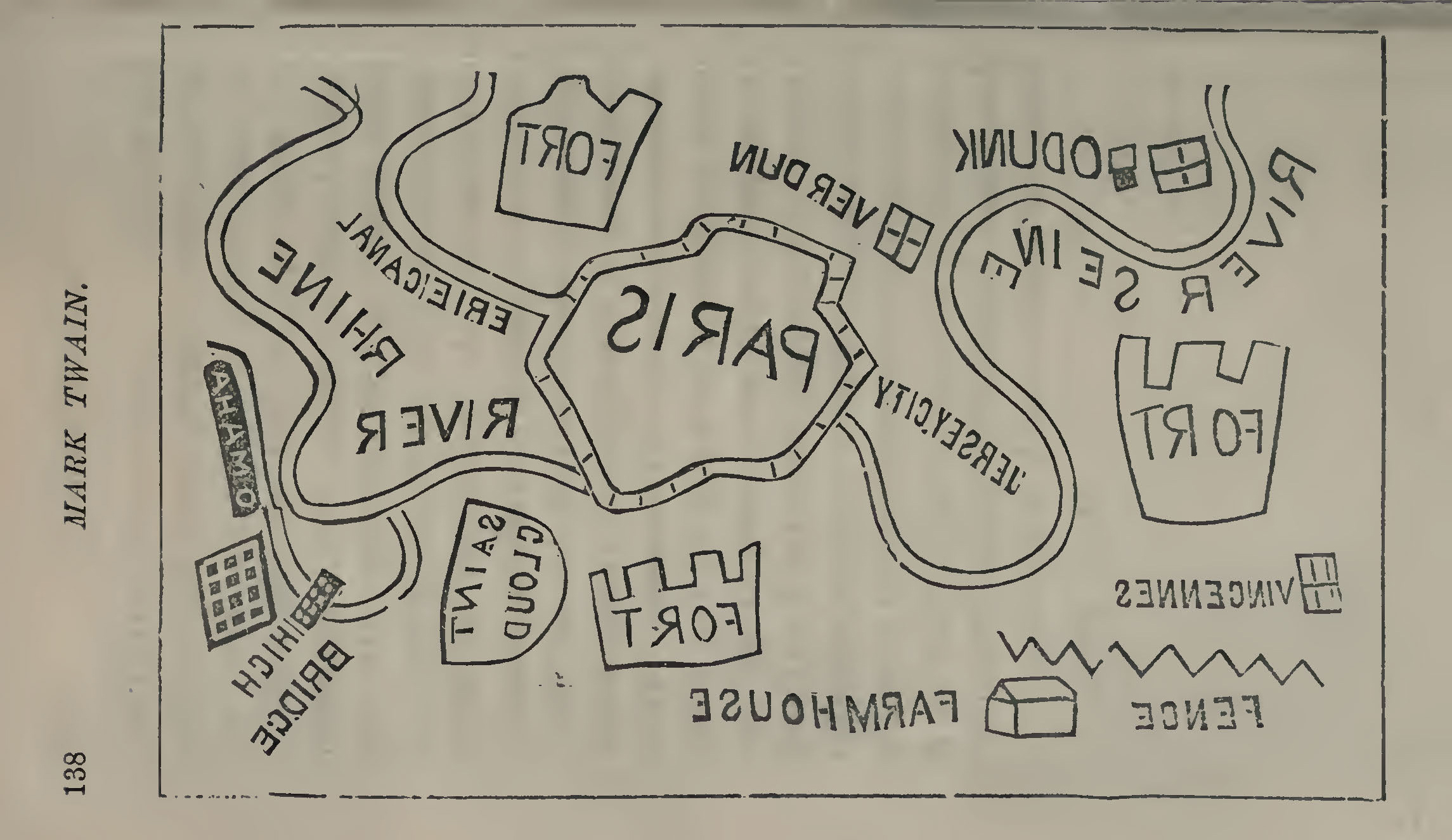
Fig. 5. Variant 2.5. Reduced version of variant 1.3 in Twain (1871a, 138), rotated for easier viewing (top at left); reproduced from archive.org. The neatline of the map measures about 8.5 × 13.5 cm (estimated).
Variant 2.6. The following year, in 1872, variant 2.5 was copied, along with the original account, for another London publication, Mark Twain’s Sketches (Twain 1872, 169–72; Johnson 1910, 19–21). The line work was further simplified:

Fig. 6. Variant 2.6. A copy of variant 2.5 in Twain (1872, 170), rotated for easier viewing (top at left); reproduced from Google Books.
Variant 2.7. Another London edition of Twain’s essays, Choice Humorous Works, by the same publisher as variant 2.5, included the map, but now with the expanded account (Twain 1873, 378–80, reprinted in a later edition, Twain 1880; see Johnson 1910, 27–29). While the map is similar to the earlier variant, its matrix was prepared anew:

Fig. 7. Variant 2.7. Another copy of variant 2.5 in Twain (1880, opp. 379), rotated for easier viewing (top at left); reproduced from Google Books.
With the war over, Twain included the map and original account in his own collections of sketches, in the 1870s and then again in 1896, eking out its use even though the immediacy of the events to which it related was well and truly over.
Variant 2.8. Yet another reduced redrawing of the map appeared in Twain’s own compilation of some of his essays, in the first (and only) issue of Mark Twain’s Sketches (Twain 1874, 26–27; see Johnson 1910, 35–36; McCullough 1972, item 44). The account is the original version. The illustrations in this chapbook were drawn by R. T. Sperry, although I see none of his hand in the redrawing of the map. The map has been reduced to about 11.7 × 20 cm, or to about 60% of the original, and it has been given a letterpress title, “Fortifications of Paris.” The clean “P” of Podunk indicates that the map was copied from variant 1.1:

Fig. 8. Variant 2.8. Reduced copy of variant 1.1 in Twain (1872, 170), rotated for easier viewing (top at left); reproduced from a scan of microfilm by Indiana University’s Wright American Fiction Project, and used here under fair use.
Variant 2.9. A few years later, Twain included the work in his collection of sketches and essays, Punch, Brothers, Punch! (Twain 1878, 26–29; see Johnson 1910, 47–49, who also identified several pirated editions published in the United Kingdom). The account is in the original version, under the title, “Map of Paris.” The map was printed from a new matrix, reduced to about 40% of the original and rather crudely done. It was set vertically on the page, with a typeset title across its top, “Fortifications of Paris”:

Fig. 9. Variant 2.9. Copy of variant 1.1 in Twain (1878, 28). 2.5 × 4.75 inches (7 × 12 cm). Photo Courtesy of Michelle Prestholt, from UW Special Collections (Mark Twain Bassett 93)
Variant 2.10. Twain later incorporated the entirety of Punch, Brothers, Punch into an omnibus collection of later Tom Sawyer novels, with the work (original explanation) under the title “Map of Paris” (Twain 1896, 405–8; see Johnson 1910, 76–77). The map was folded (trifold) and tipped in, with a typeset title underneath, “Map of Paris”:

Fig. 10. Variant 2.10. Enlarged copy of variant 2.9 in Twain (1896, 407), rotated for easier viewing (top at left); reproduced from Google Books.
The whole conceit of the “Fortifications of Paris” remained a source of reflection in Twain’s thought. In his “autobiographical dictations” to his daughter in 1906, continuing directly on from the usually quoted passage about carving the back of a wooden M in a manic phase (above), Twain could not resist playing once again with the conceit that the map was read as an authentic rendition of the military situation by contemporaries:
The Franco-Prussian war was in everybody’s mouth at the time, and so the map would have been valuable—if it had been valuable. It wandered to Berlin, and the American students there got much satisfaction out of it. They would carry it to the big beer halls and sit over it at a beer table and discuss it with violent enthusiasm and apparent admiration, in English, until their purpose was accomplished, which was to attract the attention of any German soldiers that might be present. When that had been accomplished, they would leave the map there and go off, jawing, to a little distance and wait for results. The results were never long delayed. The soldiers would pounce upon the map and discuss it in German and lose their tempers over it and blackguard it and abuse it and revile the author of it, to the students’ entire content. The soldiers were always divided in opinion about the author of it, some of them believing he was ignorant, but well-intentioned; the others believing he was merely an idiot. (“Autobiographical Dictation,” 15 February 1906, ¶14, in Twain 2010–15, 1: 362–63)
Notes
[n1] Evidence from contemporary newspapers comes from Readex’s America’s Historical Newspapers, 1690–1922 (subscription required), the Library of Congress’s Chronicling America: Historic American Newspapers, and the NYS Historic Newspapers databases. Even taken together, these are not comprehensive in their coverage of what was, even in the later nineteenth century, an exceedingly ephemeral form of print.
[n2] The editors of Twain’s papers identified some possible models for Twain’s satire, in the New York World, “The Fortifications of Paris” (11 August 1870, 1; 10 September 1870, 1), and in the New York Tribune, “The Defences and Environs of Paris” (13 September 1870, 1) (see Twain 1995, 199n1).
[n3] Since at least the 1840s, Podunk had been used in U.S. popular culture to refer to minor, out-of-the-way places that were just too insignificant to be worth mapping. The first such usage seems to have been in the “Letters from Podunk” first printed in 1846 in the Buffalo National Pilot. As Twain himself wrote in 1869, in defending the preaching of Thomas K. Beecher, a friend who had officiated at his wedding: “They even know [his preaching] in Podunk, wherever that may be. It excited a two-line paragraph there.” Interestingly, almost all of the newspapers who described the map’s depiction of American cities did not mention Podunk!
[n4] Both Steinbrink (1991, n.8 to chap.8) and the editors of Twain (1995) took Larned’s testimony to indicate that Twain had cut the block in the Express’s offices, contradicting Twain’s own testimony. But it is just as likely, given that Twain was unwilling to leave his wife at this time, that Larned visited him at home.
[n5] Steinbrink (1991, 137) thought the person “lying dead” had to be Twain’s father-in-law, as Emma Nye lived until 29 September. His father-in-law was however buried in Elmira and was not in the house in Buffalo. The editors of Twain (1995) however suggest that in his memory, Twain associated the map with Nye’s death, and so used this formula. It might also be an abbreviated phrase: “lying [as if] dead.” Either way, the reference is to Nye.
[n6] The formula in the Washington [D.C.] Evening Star (21 September 1870) was repeated in the Portland [Maine] Daily Press (23 September 1870) and in the Portland [Oregon] Oregonian (5 October 1870).
[n7] The formula in the Cincinnati Daily Gazette (20 September 1870) was repeated by the Chicago Republican (22 September 1870); the Richmond [Indiana] Palladium (24 September 1870); the Mobile [Alabama] Register (25 September 1870); the new Lisbon [Wisconsin] Juneau County Argus (29 September 1870); the Philadelphia National Baptist (29 September 1870); the San Francisco Bulletin (29 September 1870); the Sacramento Daily Union (1 October 1870); and, with minor changes, the Yankton [S.D.] Press (19 October 1870).
[n8] The formulas in the Boston Daily Journal (20 September 1870) was repeated by the Washington, D.C., Critic-Record (21 September 1870); Amherst [N.H.] Farmer’s Cabinet (29 September 1870); Lancaster [N.H.] Coos Republican (4 October 1870); Concord [N.H.] Independent Democrat (6 October 1870); and Pittsfield [Mass.] Sun (6 October 1870).
[n9] Memphis, Tenn., Public Ledger (27 September 1870), repeated by the Little Rock [Arkansas] Morning Republican (28 September 1870).
[n10] New Orleans Times-Picayune (25 September 1870), repeated by the Macon Georgia Weekly Telegraph (27 September 1870).
References
Anonymous. 1986. “Cartographical Curiosities 27: Mark Twain’s map of Paris.” Map Collector 36: 52’
Blanck, Jacob, ed. 1955–91. Bibliography of American Literature. 9 vols. New Haven: Yale University Press.
Bosse, David. 1993a. Civil War Newspaper Maps: A Cartobibliography of the Northern Daily Press. Bibliographies and Indexes in Military Studies, 5. Westport, Conn.: Greenwood Press.
———. 1993b. Civil War Newspaper Maps: A Historical Atlas. Baltimore: The Johns Hopkins University Press.
Camfield, Gregg. 2003. “A Bibliography of Works by Samuel L. Clemens.” In The Oxford Companion to Mark Twain, edited by Gregg Camfield, 675–721. Oxford: Oxford University Press.
Harrington, Paula, and Ronald Jenn. 2014. “Uncovering the French: On the Roots and Uses of Twain’s Antipathy.” Mark Twain Annual 12, no. 1: 94–112.
Johnson, Merle, ed. 1910. A Bibliography of the Work of Mark Twain, Samuel Langhorne Clemens: A List of First Editions in Book Form and of First Printings in Periodicals and Occasional Publications of His Varied Literary Activities. New York: Harper & Brothers.
McCullough, Joseph B. 1972. “A Listing of Mark Twain’s Contributions to the Buffalo ‘Express,’ 1869–1871.” American Literary Realism, 1870–1910 5, no. 1: 61–70.
Olson, David R. 1994. The World on Paper: The Conceptual and Cognitive Implications of Writing and Reading. Cambridge: Cambridge University Press.
Paine, Albert Bigelow. 1912. Mark Twain: A Biography. The Personal and Literary Life of Samuel Langhorne Clemens. New York: Harper.
Peters, Jeffrey N. 2004. Mapping Discord: Allegorical Cartography in Early Modern French Writing. Newark: University of Delaware Press.
Piatt, Don. 1871. “Funny in Spite of Himself.” Every Saturday 2, no. 71 (6 May 1871): 415.
Steinbrink, Jeffrey. 1991. Getting To Be Mark Twain. Berkeley: University of California Press.
Twain, Mark. 1870a. “Fortifications of Paris.” Buffalo Express (17 September 1870).
———. 1870b. “Mark Twain’s Map of Paris.” The Galaxy 10, no. 5 (5 November 1870): 724–25.
———. 1871a. Eye Openers: Good Things, Immensely Funny Sayings & Stories that Will Bring a Smile upon the Gruffest Countenance. London: John Camden Hotten.
———. 1871b. Mark Twain’s Memoranda. From the Galaxy. Toronto: C. A. Backas.
———. 1872. Mark Twain’s Sketches. Selected and Revised by the Author. “Copyright edition.” London: George Routledge & Sons.
———. 1873. The Choice Humorous Works of Mark Twain. Now First Collected. With Extra Passages to the “Innocents Abroad,” now first Reprinted, and a Life of the Author. London: John Camden Hotten.
———. 1874. Mark Twain’s Sketches. “Number One.” “Authorized edition.” New York: American News Company.
———. 1878. Punch, Brothers, Punch! And Other Sketches. New York: Slote, Woodman & Co.
———. 1880. The Choice Humorous Works of Mark Twain. Revised and Corrected by the Author. London: Chatto & Windus.
———. 1896. Tom Sawyer Abroad; Tom Sawyer, Detective; and Other Stories; Etc., Etc. New York: Harper & Brothers.
———. 1957. Mark Twain of the Enterprise: Newspaper Articles & Other Documents, 1862–1864. Edited by Henry Nash Smith. Berkeley: University of California Press, 1957.
———. 1976. “Mark Twain’s War Map.” North American Review 261, no. 2: 69.
———. 1994. Tales, Speeches, Essays, and Sketches. Edited by Tom Quirk. New York: Penguin Books.
———. 1995. Mark Twain’s Letters. Vol., 4, 1870–1871, Edited by Victor Fischer, Michael B. Frank, and Lin Salamo. Berkeley: University of California Press. The letters are also available online at the Mark Twain Project.
———. 1999. Mark Twain at the Buffalo Express: Articles and Sketches by America’s Favorite Humorist. Edited by Joseph B. McCullough and Janice McIntire-Strasburg. DeKalb: Northern Illinois University Press.
———. 2009–11. Mark Twain, Newspaper Correspondent: Newspaper Articles Written by Mark Twain, Collected from the Archives of Several Newspapers, 1862–1881. Project Gutenberg Australia, ebook. First posted October 2009; last updated 24 April 2011.
———. 2010–15. Autobiography of Mark Twain. Edited by Harriet Elinor Smith. 3 vols. Berkeley: University of California Press. The autobiography is also available online at the Mark Twain Project.


